The chill
light of a winter morning falls on Putney Bridge, riding a tide that rises
beyond the capital city. Having cleared the urban core, the water’s mood
changes dramatically as it swings hard to the south in a great ninety-degree
bend. Could this be a memory of 20,000 years ago, when the glaciers of the last
ice age advanced all the way down here and shunted the Thames to the south?
Coincidence
or otherwise, the bottom of that arc sends it right into what in a single human
lifetime has become the corner of the Greater London conurbation, where on
meeting the water that falls from the English interior, the sovereignty of the
tides finally ends.
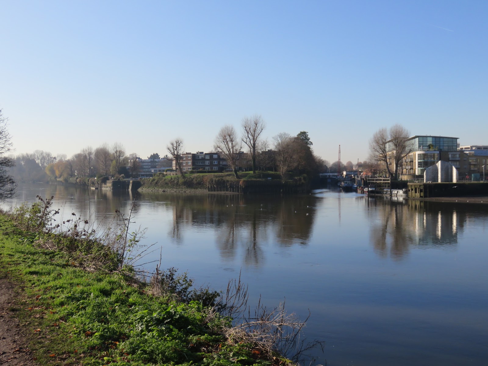
 |
| The limit of the tidal Thames, at Teddington Lock. |
But more
than water comes and goes this way. For thousands of years before trains and
motor vehicles the river was the prime means of travel for the people of its
watershed. Far better after all to let the tides take you where you want to go
than drag yourself and your belongings up and down the muddy, potholed,
bandit-ridden land routes.
If
you had the means and status for it, that is. Under English class hierarchy, this
privilege of escape from
the
struggles of London was primarily the preserve of those on the highest levels
of the social pyramid. Above all that meant the monarchy, whose palaces and
hunting grounds duly colonised all the best floodplain they could grab off the
common folk. In their wake came their obligatory orbiting constellations of
nobles, clerics, sycophants and concubines, some of whose families still occupy
these prize mansions and riverside villas. Theirs are the upriver domains of
Richmond and Kingston, towns whose roots lie in the legends of English royalty,
but the intervening distance was settled by the middle-class affluents on the next
tiers down as they popped up through the thick foam of the industrial
revolution, into the fresh river air, and followed the old nobility out that
way. Entranced by the splendour of the riverscape, these escapees imagined up
and passed down an Arcadian paradise of swans and ducks and herons, of comfortable
housing whether ruddily historic or ostentatiously gentrified, of lazy
promenades lined with elaborate lamp-posts and hanging flower baskets, along a riverside
of leaves and willows everywhere managed and in places manicured.
Yet
the question, the very English question, remains. Who is it for?
Before
we embark, ongoing events should serve as a reminder that history is alive
around us. Not two days after the
previous
section’s article there was a terrorist attack at one of its most prominent
landmarks, London Bridge. The attacker stabbed two people dead in the hall of
the Worshipful Company of Fishmongers before being shot by police on the
bridge, having been subdued by, among others, someone wielding a narwhal horn
from the aforementioned institution. This violence fed into one of the dirtiest
and bitterest general elections in this country’s living memory, in which, as
has typically been the case, the old royal lairs on the path ahead were some of
the most fiercely contested constituencies in the country. Past and future,
local and global: all are present and inseparable.
It
was not a regular election. The outcome has struck a whole new level of shock
and despair into many people and looks likely, to say the least, to irreparably
alter the destiny of Britain and England. But even in this extraordinary
instance, the boroughs of Richmond Park, Twickenham, and Kingston and Surbiton defied
both the national trend and that of London’s division into working-class Labour
Party urban areas versus white and affluent Conservative Party sub-rural
outskirts. This corner alone chose a third option and put in Liberal Democrat
MPs with comfortable majorities:
the sole phalanx of Lib-Dem amber on a map that has otherwise scattered it to particles.
Pinned
between core and periphery; shaped by both upstream and downstream worlds but
not entirely of either. Who are the people who live on the riverbend, and what
makes them different?
Start:
Putney Bridge (nearest stations: Putney Bridge, Vauxhall)
End:
Kingston Bridge (nearest station: Kingston)
Length:
20.9km/13 miles
Location:
Greater London – Borough of Wandsworth, Borough of Richmond upon Thames, Royal
Borough of Kingston upon Thames
Topics:
University Boat Race, Barnes, Hammersmith, Chiswick, Mortlake, the National
Archives, Kew Gardens, Syon House/Abbey, Richmond, Isleworth, Twickenham,
Teddington Lock
Barnes Peninsula
Here,
unusually in this land, is a place whose name sounds like what it meant.
The Barnes peninsula was named for its granary barns that supplied the
manor of Mortlake, of which it was part till Barnes village grew in its own
right.
These
low-lying fields were more isolated than nearby Putney. As Barnes village
abided on the west side of the peninsula, the farmlands and estate grounds on
its east, named Barn Elms, seemed to preserve more of the river’s
wild underlying character.
 |
| The view up the east flank of the Barnes peninsula. The outskirts of Putney are
on the left, the grounds of Fulham Palace on the right. |
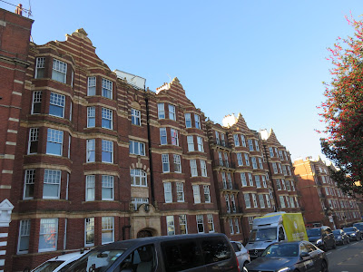 |
| On the Putney riverside the stylish bricks and stripes of Kenilworth Court,
built in the 1910s, offer a flavour of the storied affluence ahead. |
The
riverbank out of Putney is lined with rowing clubs, which could be taken as a
sign of a recreational turn in land use if you are prepared to stretch the
definition of ‘recreational’. In English professional sports, especially those
with a certain status in its elite public school establishment, competitive
rowing can be observed to occupy a place further from recreational and closer
to military, with a seeming purpose not so much in propelling one’s boat faster
than other people’s as in turning hapless youngsters into ferocious, red-faced,
iron-disciplined, burning-sinewed engines of destruction.
Perhaps
I carry some bias here, having encountered that rowing juggernaut years ago in
the course of exploring more peaceable boat-racing cultures on this river
(punting, if you must know – maybe more on that further upstream). Either way, it is one of the pinnacles of that
rowing culture that does most to fix the following stretch of the Thames in English imagination.
 |
| A long slipway caters to the stampede of rowboats in and out of Putney’s rowing
clubs. |
 |
| Most of the clubhouses here are held by select public schools, corporations,
or other organisations with a distinguished rowing tradition. I have never
rowed, but have come here before. The memories are difficult. Not for obvious
reasons. We shall not discuss this. |
 |
| Putney Bridge in the morning haze. It is here that the Oxford and Cambridge
University Boat Race begins. |
In
February 1829, a letter made its way from a college of the University of
Cambridge to the University of Oxford, challenging the latter to a rowing race
‘at or near London, each in an eight-oared boat during the ensuing Easter
vacation’. This race was held far upriver near Henley, but when they gave it a
second go in 1836 they brought it here to London. In no time ‘The Boat Race’
had grown into an annual tradition, held every year since the 1850s except
during the world wars.
Because
this was and is a sexist country, all these race crews were men. Sports and
elite academia both tend to be bastions of misogyny in such societies, likely due
to men’s fear that any reminder of women’s strength or intellect, respectively,
would re-awaken women’s power to annihilate those patriarchal power structures
by demolishing the fragile lies on which they are built. A women’s race began
only in 1927, more than a hundred years after the men’s, held in Oxford with
crowds of people on the riverbank jeering their offence at the idea of women
rowing. Not until 1964 did the women’s race stabilise as an annual event, and it
was only in this decade – yes, that’s right – that it came here to the same
course as the men’s, although the two are still held as separate races.
The
Boat Race quickly became a fixture of the English cultural calendar. Every year
it brings excited crowds onto the riverbanks ahead, where they pack the pubs
and cram onto the bridges to cheer for the racers as they pass, while millions
more follow it on television or the radio. Both universities take the race
seriously as a reflection of their increasingly interrogated prestige and set
their teams preparing months in advance, so both have had their share of
victories, though as of this year Cambridge is slightly ahead in both men’s and
women’s races.
 |
| There are rowers out this morning for early training. A typical English rowing
party is led by a megaphone-toting totalitarian in a motor boat, who motivates
the rowers by bellowing public humiliation of their every motion to all people
in hearing range. |
 |
| Across the river are the grounds of Fulham Palace, residence of the Bishop of
London from the eleventh century to 1973. It has now been restored as a public
museum with gardens and a café. Fulham itself, traditionally a centre of
crafting and brewing, takes its name from someone called Fulla in
Anglo-Saxon Old English. The suffix is not from the more common ham,
meaning a hamlet or homestead, but hamm (obviously completely different)
which means a river bend. |
At
the end of the rowing base arrives the Beverley Brook, a Thames
tributary from the green fields of Merton to the south. With it a significant
threshold is crossed, for this is the start of the towpath. It is the
first point on this route where the paved or cobbled urban riverside gives way
to a dirt track.
 |
| The Beverley Brook’s name indicates that beavers lived in it, but the English
allowed them to go extinct around the sixteenth century. Then they horribly
polluted the river with sewage, but more recent efforts have improved its
biodiversity and it is now a special conservation area. Wouldn’t it be nice to
have the beavers back? |
Despite
towpaths’ popularity with joggers and dog-walkers today, they were built
so people or animals could haul boats along before the advent of industrial
engines. They are a common feature along England’s canals, where they were
specifically designed for horses, but since these functions were made obsolete
by road, rail and air travel towpaths have largely survived by turning into
recreational walking or cycling tracks.
And
indeed, it is people out for just that sort of casual exercise who seem to
populate the Barn Elms towpath today. On top of that, their strolling is of a
class register distinct from people downriver. In general they are whiter,
older, in less of a hurry, and converse in Received Pronunciation about their
relatives’ conformity to bourgeois norms like the nuclear family, education
ladder and pretend monogamy. On a brighter note, there are lots of pleasant dog
encounters to be had too.
 |
| Opposite the towpath used to stand a picturesque cottage, built in 1780 by a certain
noble called William Craven. It went through a series of wealthy hands before
burning down in 1888, but its ruins drew the attention of the newly-formed
Fulham Football Club. Within two decades they had built their home stadium
there, which sustained them right through to their Premier League efforts a
century later while never relinquishing its inherited name of Craven Cottage.
It is currently sacrificing its guts to be devoured by these colourful beasts
so it can reincarnate with a larger crowd capacity. |
 |
| This is clearly a managed riverside, with trees tagged and cropped and paths
kept in good condition. |
 |
| The manor of Barnes eventually grew up under the control of the clerical
authorities of St. Paul’s Cathedral, but Queen Elizabeth I of the Tudor dynasty
bought it off them in 1579 and gave it to Sir Francis Walsingham, her
secretary, spymaster and political fixer. Many of the manor’s old grounds are
now playing fields. |
Hidden
over that grassy brow is possibly the Barnes peninsula’s richest treasure.
Where formerly languished some obsolete reservoirs now spreads the
London Wetland Centre,
whose hundred acres of wetland habitat are the new home for a thriving community
of feathery creatures.
It was opened
only in 2000 but the organisation which runs it, the Wildfowl and Wetlands
Trust, was founded in the 1940s (by Peter Scott, son of Captain Robert Scott of
Antarctica fame) and has long campaigned for the protection of these critically
important wetland environments.
These
green and pleasant lands contrast with a more muddled mix on the north bank.
Through the old Middlesex settlements of Fulham, Hammersmith, Chiswick and
Brentford, the entitled landowners and middle-class city escapees jostled with
millers, brewers and boat-builders who approached the water out of industrial
and commercial interest, if usually with smaller spheres of influence than the
City big beasts. The result is a patchy mosaic of prosperity and poverty that
continues as the regeneration brigade makes its move on those that did not make
it into the new millennium.
 |
| Thames Wharf in Fulham used to serve the Duckham engineering company which produced
lubrication oil for machines. The depot closed in 1979 and was converted into
the present Thames Wharf Studios (at left), with its former canteen becoming a
famous Italian restaurant. |
 |
| Further up the Barnes peninsula stands this incongruous facsimile of Harrods
department store in Knightsbridge: renowned, exclusive, and currently owned by
the state of Qatar. This is in fact its old furniture depository, completed in
1913 as a warehouse for whatever wouldn’t fit in the main store, as well as to
look after the belongings of people travelling overseas to serve the British
Empire. It was positioned on the river for easy movement of goods on and
off barges by crane, and is now – of course – extremely expensive apartments as
part of the rebranded ‘Harrods Village’. |
 |
| Hammersmith Bridge. |
The
appearance of Hammersmith Bridge in 1827, the Thames’s first suspension bridge,
finally flung the noose of civilisation round Barnes’s neck. But like
so
many of the downstream bridges it began to buckle under traffic, especially
once the Boat Race got popular and over ten thousand people at a time crowded upon
it to watch. So they replaced it in 1887 with the current structure, another
Joseph Bazalgette design, but while admittedly attractive – not to mention
strong enough to survive three IRA bombings – it did not match the other new
bridges’ success at handling modern traffic loads. After years of on-and-off
closures it is now shut to vehicles indefinitely while they work out what to
do.
 |
| The closure of Hammersmith Bridge provided a delightful political football
for Zac Goldsmith’s Conservative Party over in Richmond, which enjoyed regularly
beating the Labour Party-controlled Hammersmith and Fulham council about the
head with it. Presumably this is because they’d prefer the spectacle of its
collapse dumping cars and screaming pedestrians into the river so they could
blame them for that instead. Goldsmith held Richmond Park constituency by a majority of 45 but was kicked out in the December 2019 election, in the face of the national trend, in favour of the Liberal Democrats' Sarah Olney. |
Hammersmith
itself is thought to have been an old Anglo-Saxon fishing village, with its
name suggesting a notable blacksmith or forge. Its main draw was that its
ground was gravelly rather than marshy, making it attractive both for the
monied escapees’ villas and for small-scale riverside industries. Some of
these also made use of a tributary long vanished into the local sewers, whose
name, which survives in Stamford Brook station on the District Line –
from ‘stony ford’ – likewise whispers of stabler earth here. Today Hammersmith
is a jumble of offices, shopping centres, arts venues and pockets of
architectural heritage, anchored around its service as a major transport
junction.
 |
| The waterfront of Hammersmith, with its embankment, low-rise buildings and
riverside pubs. |
 |
| In contrast the Barnes side remains leafy and recreational. Concealed through
the dense curtain of foliage is St. Paul’s boys’ school, one of England’s elite
public schools that was founded in the City by St. Paul’s Cathedral, hence the
name, but moved here in the 1960s onto land made available when Barnes’s
reservoirs were filled in. |
There
then appears the first of several small river islands that string the meanders
ahead. The locals call them aits or eyots, a very old term with
the same Old English root as the word island which this area – perhaps
in a sign of its own insularity? – has somehow preserved separately.
The
first of these, Chiswick Eyot, shields the district of Chiswick from
view. Like Hammersmith it has long served as a transport hub, being on both the
river and the west road, and grew as a community with a complex economy of its
own. As well as the fishing and boating there was farming: they cultivated
willows (‘osiers’) on the Eyot for making baskets and furniture, and the barley
grown here was said to be particularly good, which in turn made Chiswick a
prominent beer-brewing centre. This status consummated in industrial times when
it produced Fuller, Smith and Turner, better known as Fuller’s, who still run
pubs up and down the country on the output of their famous Griffin Brewery.
 |
| The Griffin Brewery casts a malty fragrance across the river, while the
remainder of Chiswick is largely hidden by Chiswick Eyot. Fuller’s was a
family-run business for over 150 years, but at the beginning of 2019 they caused
shock by selling their entire brewing operation, including this facility, to Japanese
beer company Asahi in a choice to focus instead on their more profitable pubs
and hotels. |
 |
| Church Wharf, a little upriver of the brewery past Chiswick’s church. In the
1860s the Thorneycroft father-and-son partnership came and installed a ship-building
works here. Their high-speed ships featured creative design innovations, and
eventually they supplied torpedo boats and destroyers for the Admiralty. It is
said every time a ship was launched here the ceremony drew crowds of excited
spectators, which must have been quite a sight, but soon the destroyers grew
too big for London’s bridges and after too many obstructed masts and hulls
stuck in mud they moved the works to Southampton. The area remained industrial
till the 1980s and 90s, when housing developments became more profitable, but
the houseboats around the pier preserve a hint of the old connection with the
river. |
 |
| The birdsong here is noticeably richer than in the urban core. Green parakeets,
who have very effectively conquered large swathes of several cities worldwide,
have powerful strongholds in this corner of London. |
 |
| The rest of Barnes’s disused reservoirs are now the designated Leg O’Mutton
Nature Reserve. Look, I don’t come up with the names here. |
Only
then, down the peninsula’s west flank, do you come to Barnes itself. The
village is old, at least twelfth-century, and was relatively remote and
agrarian till they opened Hammersmith Bridge, followed in the 1840s by a
railway link. Its farmers and gardeners could now more easily sell stuff across
the river, while London’s escape middle class found in it a fresh place of
refuge. Steadily suburbanised, they have nonetheless made efforts to preserve
the old village’s picturesque heart with its green and pond.
 |
| The Barnes waterfront. The railway bridge is an 1890s replacement of the
original 1849 structure, and like most large buildings and bridges along here
has become a popular landmark in the Boat Race. |
 |
| This key probably drains the river. Have they tried turning their country off
then on again? |
 |
| Barnes’s riverside street, called The Terrace, started sprouting elegant little
mansions in the eighteenth century when it was still relatively isolated.
Numerous notable cultural figures were drawn out here over the years. The blue
plaque identifies this as the house of composer Gustav Holst in the 1910s,
shortly before he wrote The Planets. |
 |
| A seventeenth-century pub at the edge of Barnes, with Mortlake visible in the
distance. |
The
centre of Barnes is still quite small, and its riverside soon blends into Mortlake.
This was the dominant manor in the area stretching south into what is now
Richmond, but the riverside village itself was limited to a single street,
while the rest – now a London commuter suburb – was predominantly rural. It
might have stayed a nondescript fishing settlement – its name implies a stream (lacu)
with salmon (mort) in it in Old English – had not King James I financed
the creation of a major tapestry works here in 1619, staffed mostly by skilled
Flemish weavers from what is now Belgium.
Most
of Mortlake’s development took it away from the river, where its main landmark
is another big brewery. Unlike Fuller’s in Chiswick, Mortlake’s Stag Brewery
changed hands several times and was finally closed down after 2010.
 |
| The old heart of Mortlake. The concrete Chiswick Bridge was added in 1933 to link
it to the Chiswick peninsula as both settlements’ populations grew. The head of
the latter is now dominated by sports fields. |
 |
| This area has fewer embankments and river walls than downstream, making it far
more vulnerable to flooding. After heavy rains it is common to find these
waterfront paths completely submerged. |
 |
| The former Stag Brewery. Its final operator was the American brewing company
Anheuser-Busch which produced beer for its Budweiser brand here. |
 |
| The derelict brewery was sold in 2015 to a Singaporean development company and,
like so much else, is slated to be turned into apartments. |
Mortlake
effectively ends at Chiswick Bridge, which also overlooks the finish line of
the University Boat Race. The Ship pub, which sits in the shadow of the
brewery and is hundreds of years old, has been one of the biggest beneficiaries
of that when once each year its premises and riverfront swell into a heaving
mass of triumphant inebriation.
 |
| The Ship. The road in front is also heavily exposed in flood conditions,
and there are warning signs advising that parked cars can be washed away. |
 |
| Chiswick Bridge. |
 |
| Just short of the bridge is the finish line of the University Boat Race
(‘UBR’), marked on both sides of the river. |
Kew Peninsula
Here
the Thames turns south. In so doing it defined this corner of land for the
people who first named it Kew, or Kayho as it used to be: a hōh,
or spur of land, described for its key (quay) or cæg
(key shape).
Kew emerged
much like its neighbouring districts out of the royal leisured interest in escaping
London by river, but then took a turn in completely its own direction as its
gardens sprouted exotic plants and drew in specialist botanical researchers. While
it charted a unique path of its own round the outside of the river bend, the east
side remained a little more isolated. The large Mortlake Cemetery appeared here
to catch Hammersmith’s overspill, as did a sewage treatment plant.
 |
| The sewage farm was closed in the 2000s and has now been replaced by this Kew
Riverside housing development. It is directly accessible from the towpath and will
be in serious trouble once sea level rise and storm surges overwhelm the Thames
Barrier. |
 |
| Over the years I have had personal encounters with the Thames in several
places. Here I once shook hands with Death. We shall not discuss it. |
Then,
in 1977, Kew’s eastern backyard was joined by a major public institution, the
most important of all as far as history is concerned. The National Archives,
formerly the Public Record Office, moved here when its old home on Chancery
Lane in the City began to run out of space. This is the official public archive
of England and Wales (Scotland and Northern Ireland have their own), and looks
after an enormous treasure trove of documents going back more than one thousand
years: government papers, legal records, maps and plans, statistics, correspondences,
wills and other materials, a great deal of which anyone can browse online and
make bookings to come view the originals.
Some
of England’s fabled national treasures are kept in this collection, including
the
Domesday Book
and one of the four 1297 re-issues of the Magna Carta. But perhaps richer still
are its fragments from a millennium’s worth of lives lived up, down and across
English society, into which even a random sample can give startling and
remarkable insights. Indeed, a large number of people who come here are private
individuals investigating their own family histories.
 |
| The National Archives complex, of which a better view is afforded from the
windows of the District Line between Gunnersbury and Kew Gardens stations. I
recall exploring its records before travelling to Guyana and
unearthing records from its departure from the British Empire in the 1960s,
including a letter to the British queen from an indigenous Guyanese concerned
about his country’s ethnic strife, which began: ‘Well Mrs. Elizabeth II…’. With
it was stored a reply from a Foreign Office mandarin telling him that as Guyana
was now independent, he should direct his concerns to its new president. |
A
more curious aspect of the National Archives site is that it has a little
nature reserve in its corner, claimed to house one of Britain’s only
communities of the extremely rare Two-Lipped Door Snail (Alinda bilplicata).
 |
| Kew Railway Bridge gets the Richmond branch of the District Line and the London
Overground across the river. This bridge is the 1869 wrought-iron original.
Along its east riverbank, considered the outskirts of Chiswick, is an
attractive stretch of eighteenth-century pubs and small houses known as
Strand-on-the-Green. |
 |
| Another small island, Oliver’s Ait, is named after Oliver Cromwell because of a
story that he took refuge on it during the civil war, though there is no
evidence to support this. It has featured a City toll booth for river vehicles,
boat repair works, and a Port of London Authority (PLA) storage depot, but now
has no structures and is managed by the PLA to support wildlife. |
 |
| Around the riverbend the gentrifiers of Brentford raise their cladded banners. |
Brentford,
Kew’s counterpart across the river, is distinct. It sits on the Great West Road
and crosses another tributary, the Brent, right where it spills into the
Thames (hence Brent-ford). This is a very old river, with both its name
– of deep Celtic origins – and the settlement at its bottom well pre-dating
Roman London. Heavily worked in industrial times, it expanded in human
importance many times over when they connected it to the Grand Junction Canal –
now the Grand Union Canal – in the 1790s, thus making Brentford the link
between London and the national canal network which served as the bloodstream
of this country’s industrial revolution.
With
so many people and goods moving through its strategic situation, Brentford
emerged as a bristling commercial and industrial centre. For a long time it was
in effect the provincial capital of largely agricultural Middlesex, a barnacle
of hard work and seedy political fisticuffs on a reef of indolent country
mansions. Its factories, workshops and wharves coexisted with market gardens
and prosperous professional neighbourhoods in a flux reminiscent of
the
Thames below London in microcosm, and despite the collapse of English
industry this continues today. Now it is the unaffordable-housing regeneration
squads who descend on Brentford, along with numerous large corporate
headquarters taking advantage of its position at the head of the latest corridor
to the west, the M4 motorway; their employees, in suits and ties, walking to work
through derelict warehouses and haunted boatyards.
 |
| Because both Kew and Brentford were significant, a bridge has joined them as
far back as 1759. The present granite Kew Bridge is the third, opened in 1903.
Notably all three were opened by either the contemporary king or his heir, perhaps
reflecting how attached they were to their Kew paradise. |
 |
| Brentford’s formerly wharf-lined riverfront has been a glistening prize for the
gentrification brigade. Much of the town is a massive construction site at
present, the centrepiece being a new stadium for Brentford Football Club which
currently plays at Championship level. The brick tower is one of Brentford’s
icons and belongs to the old Kew Bridge Pumping Station, now the London Museum
of Water and Steam. |
Brentford
has its own ait, a great long one which shields much of the town from
view. Apparently this was deliberate: it was planted with tall, thick trees in
the 1920s so visitors to Kew Gardens, by then open to the public,
wouldn’t have to see Brentford’s gasworks.
 |
| Brentford Ait. |
 |
| The river Brent comes in from the west, having passed through Brentford’s locks
where goods coming down the canal were weighed and charged tolls. Brentford was
also the site of a small but extremely significant battle in 1642, early in the
civil
wars. On their way in to take back London the Royalists overcame a small Parliamentary
force defending the ford town, but robbed and abused the citizenry such that a
huge throng of angry Londoners then came out to confront them alongside the
Parliamentary army up the road at Turnham Green. Taking London might have ended
the war when it had barely begun, but unprepared to risk a monumental bloodbath
the king’s forces fell back upriver, ultimately spreading the war across the
country. |
The
Royal Botanic Gardens are what really made Kew’s name, and in their field that
name is internationally celebrated. With a collection of some 8.5 million
varieties of plants and fungi it is one of the largest and longest-established
botanical gardens in the world. It is a leader not only in the aesthetics of
the English gardening tradition – attractive landscapes, spectacular greenhouses,
colourful flowers and so on – but also in its scientific work of collecting,
studying and conserving a planet’s worth of flora. Its massive banks of seeds,
tissues and DNA from countless plant species ought to be useful one day if, as
presently seems likely, humankind persists in its intent to wipe out as much
life on Earth as possible.
That
such an installation took root here, in this corner of the Thames, seems an
interesting accident of history. Kew marks the start of a long and continuous
stretch of pleasant riverbank which, because of that pleasantness, was
monopolised by successive English royal dynasties. Their interest in Kew goes
back at least seven hundred years, intensifying as it was drawn into the orbit
of Tudor Richmond in the sixteenth century and soon sprouting a Kew Palace
complex of its own. Its occupants were hardly atypical for their class in their
enjoyment of green and pleasant landscapes with not a pauper or political
dissident in sight, but it so happened that some of them, in particular
Princess Augusta of Saxe-Gotha-Altenburg (of the Hanoverian dynasty – these
were Germans), had a more eccentric flavour of gardening interests and in the
1760s had the gardens filled with exotic plants and fantastic structures like a
towering Chinese-style pagoda.
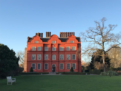 |
| This is the ‘Dutch House’, the only surviving part of Kew Palace. Kew
Gardens is not accessible from the riverbank and must be entered through its
own sets of gates, so this and the following pictures are from separate visits. |
This
in turn drew the attentions of professional botanists, all of them children of
the confluence of the currents of science, industry and empire that now began
to propel the English to a new level of power in the world. These were serious researchers
who passionately devoted themselves to collecting as many specimens as possible
and studying them to smithereens so that an empirical understanding could be
built of plants’ relationships, ancestries, medicinal uses and economic
applications, whether for the fun of it or to better serve the higher mission
be it divine, Enlightened, Imperial or all of the above. Initially they worked
with the blessing of the royal landowners, but by 1840 had turned these gardens
into a research centre of such unique and potent national significance as to
press them out of the crown’s hands and into government ownership, opening them
up to the public that same year.
 |
| Kew’s 1762 Pagoda, which has just come out of a twelve-year
refurbishment. The original dragons on the eaves rotted away in the rain within
a few years and have now been restored after a two-century absence. This time
they are supposed to be more weather-resistant because they came out of a 3-D
printer. |
 |
| The Palm House, built in the 1840s. Kew’s grandest greenhouse maintains
permanent tropical conditions to look after a towering assembly of rainforest
plants. |
 |
| The gardens have a large artificial lake that brings in diverse waterfowl, many
of whose species are uncommon and – speaking from personal experience – beakily
opinionated. They don’t observe humans’ boundaries, so fellows like this on the
towpath are frequent encounters in Kew Gardens’ wider neighbourhood. |
This
too fits a pattern in these parts: of estates once closed off for the
enjoyment of the English ruling class, eventually relinquished, with varying
degrees of struggle, so that ordinary people can now enjoy it too. But facing
Kew across the river is an opposite case: of land seized by the entitled
classes and kept ever since. Granted, most of Syon House, and its
grounds of Syon Park, are also open to the public despite being the
London residence of the Percy family, known in the nomenclature of English
nobility as the Dukes of Northumberland. It even has a garden centre, of all
things, and a café. But in that café’s outdoor seating area can be found an old
stone barn. It does not fit in the picture because it is the last remnant of
what stood there before the house appeared, at around the same time as Kew’s committedly
botanical turn, and the secrets it harbours are dark and bloody indeed.
 |
| Syon House, with the lion of the Percy family crest on top. |
Before
Syon House there was Syon Abbey. This was one of the later of England’s
old Christian monasteries, arriving here in the 1430s with a community of
mostly nuns, along with a few male priests, who were followers of Saint Bridget
of Sweden (the name Syon is from Mount Zion outside Jerusalem). In
contrast to monastic stereotypes, this was a resolutely strong-womaned order known
for the leadership of its female members as well as its promotion of
independent thought and critical engagement in the political and worldly
affairs of the time. The abbey they founded here was said to have grown into a
thriving hub of cultural exchange, economic activity and cutting-edge
scholarship, run by literate people from world-curious and often well-travelled
backgrounds, and frequented not only by pilgrims but by the leading political
and intellectual heavyweights of the day such as Katherine of Aragon and
the great Dutch humanist Erasmus.
Until,
that is, King Henry VIII
brought
his sledgehammer down upon it in the 1530s. Like many religious
institutions in this country, the nuns and priests of Syon Abbey were willing
to make compromises but could not in good conscience accept the king’s demand,
by law, that they accept him, not the Pope, as the supreme religious authority
in England. After they insisted as much to Henry’s enforcer Thomas Cromwell and
his heavies, the authorities decided to make an example of them by dragging
away one of their top priests, the Cambridge-educated humanist scholar Richard
Reynolds, so they could publicly cut off his parts and burn them in front of
him – penis, then guts, then head – along with dissident priests from other
monasteries. They then returned one of his limbs to Syon Abbey, dangling it
above the front gate in an attempt to terrorise its nuns into submission.
Instead
the nuns demonstrated the correct response to authoritarian violence by
redoubling their resistance. Cromwell and his inspectors bombarded them with
threats and enticements for years on end, but none of it so much as made a dent
in their iron wall of integrity. Only when Henry escalated his assault into the
total subjugation of the English monasteries and seizure of their property did
Syon Abbey fall – and even then the sisters refused to surrender, but rather
packed up and left the country, carrying with them both the keys to the abbey
and the bit of pillar where a hanging chunk of one of their own had failed to
intimidate them.
For
them there followed an epic exile of three hundred years through an unhinged
and warmongering Europe: from the Netherlands, to France, to Portugal, through
riots, religious warfare, pirates, hunger, disease, the monstrous Lisbon
earthquake of 1755 and hostile political and social forces, even from their own
Catholic authorities in Rome who tried and failed to impose the authority of
male bishops on them. In spite of all these trials it is said they managed to
maintain their serene monastic equanimity, entertaining curious locals and
travellers and baking cakes for them regardless of their religious persuasions.
At long last they made it back to England in the 1860s, still holding the
pillar fragment that had dangled Reynolds’s body part, as this country’s
anti-Catholic hatreds were at last simmering down. They settled in Devon, the
only English monastic community to survive Henry VIII’s purge.
As
for their old Abbey buildings here, the royals kept them for a time as a useful
waypoint on the way upriver to centres like Hampton Court and Windsor Castle. They
then passed through a series of entitled hands before ending up with the Dukes
of Northumberland, who had them rebuilt and landscaped into the mansion they
are today. But the Abbey’s genius loci got one last symbolic revenge on
Henry VIII before following its community out on the tides. As he took over the
church, the king had been confronted by a priest who warned he was like the
arrogant and corrupt Bible character Ahab, who ended up with his blood licked
by dogs. Sure enough, after Henry died in 1547, his morbidly obese and
gout-stricken corpse spent a night here at Syon on its way to Windsor Castle.
Bloated, putrefying and having spent a day rattling on the roads, it is said
that it exploded out of its coffin, and when the repair crews came in the next
morning they found some local dogs lapping away at his blood.
 |
| Lick, lick, lick. Woof. |
Richmond
Further
inside the riverbend stands a hill. From some angles it might even look like a
strong hill, or for Norman French speakers like the medieval English, a riche
mont. It was Henry VIII’s dad, the Tudor dynasty founder Henry VII, who
gave it this name when it brought to mind the Richmond in his Yorkshire earldom
(although his family was originally from Wales).
 |
| From Kew Gardens to Richmond most of the riverside looks like this. |
Previously
the land from here to Mortlake was called Sheen, pragmatically meaning sheds
or shelters (compare Barnes). The transformation of the west part
into Richmond is why you still find East Sheen on maps, but no West Sheen (or
indeed North Sheen, now absorbed into Kew). The centrepiece of that
transformation was Richmond Palace, which no longer exists. Its grounds
stretched up to Kew and included the fields between, now known as Old Deer
Park since their use in the Stuart period as a deer-hunting park.
 |
| A great swathe of Old Deer Park, seen here through the trees, has been turned
into the Royal Mid-Surrey Golf Club. There is also a rugby field. |
 |
| This marker invites you to imagine a straight line running through its slit, via
the obelisk, to the faintly visible observatory in the background. The
observatory was installed by King George III of the Hanover dynasty (of losing the
American colonies and The Madness of King George fame), and together
with the obelisks marked a meridian used for setting time before the
introduction of Greenwich
Mean Time. |
 |
| Look, they did a science. |
Any
of the monarch’s extended family enjoying Old Deer Park might have had a view
across the river to Isleworth. This ancient hamlet rose to prosperity in
the orbit first of Syon Abbey then the Duke of Northumberland’s Syon House, though
even before those its own little port is said to have received trade vessels
from as far as France and Scandinavia. The settlement pre-dates England, being
named for the enclosure (worth) of someone called Gīslhere,
who lost the G at some point but still bequeaths an s they do pronounce
in this case. Any tongues yet undefeated can then try the Anglo-Saxon charter
of 677, where it appeared as Gislheresuuyrth.
 |
| When the railways arrived in the 1840s, the rich nobles migrated further out
and Isleworth became more commercial, with bountiful market gardens supplying
the capital city. These receded as the urban professional classes took over,
and lots of Isleworth’s characterful old neighbourhoods have now been devoured
by the gentrification brigade. The riverside church is an architectural jigsaw
puzzle whose tower, one of its oldest pieces, is about seven hundred years old.
Just visible at left is Isleworth Ait, which despite being a nature reserve has
swallowed much of the discharge from the Mogden Sewage Treatment Works whose
arrival in the 1930s ruined south Isleworth. |
 |
| Isleworth’s The London Apprentice pub, on record in 1731, overlooks the
position where the Richmond Palace ferry used to run. Its name establishes the
reach of the City
of London livery companies all the way out here, whose apprentices would
apparently row up to celebrate at this pub on their qualification as
journeymen. It appears Father Christmas has got stranded on its balcony. |
 |
| A former boathouse, transformed in the Hanoverian period into this pretty pink
pavilion. |
The
approach to Richmond crosses another threshold: the first lock on the Thames
itself. Richmond Lock is the only Thames lock controlled by the Port of
London Authority (PLA), and combines the functions of a lock, a weir and a
footbridge: that is, it lets ships pass between different water levels, causes
that difference in the first place, and allows pedestrians to cross the river. It
was built in the 1890s because the demolition of the old London Bridge with its
stacks of houses removed what had effectively been a dam, causing the tides to
fluctuate much more intensely. Added to the effects of the Teddington weir upstream,
this left the river past Richmond a muddy trickle at low tide. Richmond Lock
addresses that by maintaining a navigable water level above it when the tide
goes out.
 |
| Richmond Lock. I have memories of this striking structure from a few short
years in earliest childhood spent near here. But we will not discuss this. |
Richmond
Lock signals a changing phase in the river’s course. We are now high enough
above its mouth that the human inhabitants felt confident enough to dare make
large, planned interventions into its rhythm, at least until they found the
technology to build the Thames Barrier in its throat many years later. The tide
still reaches up the river beyond here, but it is mitigated now, and soon
concedes the rest of it.
 |
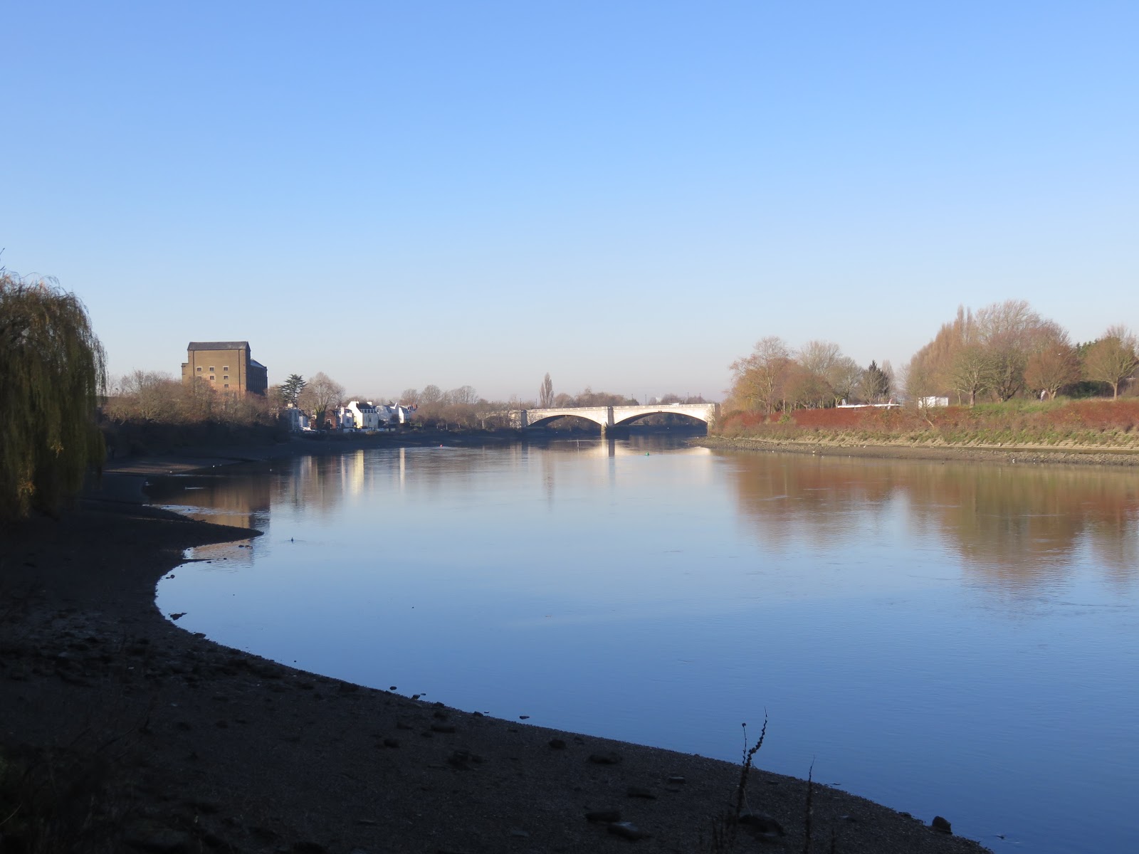
| Twickenham Bridge. Until this was built in 1933 there was no road crossing between
Richmond and Kew (though pedestrians got Richmond Lock in the 1890s). The
railway bridge behind it is from 1908, but replaced an older bridge carrying
trains further up the Thames valley since 1848. |
 |
| Beyond the bridge, Richmond materialises round the corner. |
It
was here that Henry VII of the Tudors built his Richmond Palace and in
so doing birthed what would later grow into a relatively prosperous London
suburb at the end of the District Line. Though the palace has vanished without
a trace it was a serious piece of work, and its founder, remembered as a more
shrewd and sober character than his son, sank considerable resources into
developing it. In a way it is surprising there is next to nothing left to mark
its existence, given that the creator of English modernity’s foundational
dynasty both built and died in it, as did that dynasty’s consummator, his
granddaughter Elizabeth, whose passing here in 1603, after much enjoyment of
this palace and hunting in Old Deer Park, brought that dynasty to an end (Henry
VIII for his part disliked the palace and largely ignored it). On top of that, it
was not long after building the palace that Henry VII watched his own daughter
get married to the king of Scotland here, an event which meant that a century
later it was the Scottish monarchs, the Stuarts, who would travel down to
inherit Elizabeth’s crown.
 |
| The palace met its end in the civil wars, when after
killing the king, Parliament confiscated and sold it off as it did many
royal holdings. It was demolished for building materials soon after. But the
supporting town endured, and became fashionable as the Hanoverian nobility’s
mansions and lodges sprouted round Richmond’s hill and park over the following
century. Richmond remains a pocket of relative wealth with many surviving
houses and civic buildings from that period. |
The
stretch beyond the palace site is now Richmond’s main waterfront. By here it is
clear we have crossed to a different world from London. Gone are the pirates,
gibbets, fortress docks, industrial effluents and towers of doom whose shouts and
shadows shroud the metropolitan Thames. Instead, the monied castes who ran all
that, rather than living in it themselves, found in Richmond the perfect
template for an alternative vision just for them: the Thames romance of an Arcadian
world, a green and pleasant land right out the gates of their mansions with idyllic woods and meadows and drooping willow trees. The river was there not
for work – that was something people who did not exist did far away – but for staring
at dreamily or pleasure-boating on in skiffs and wherries, especially once the
canal link to Brentford meant the working barges no longer had to inflict
themselves on the picture.
 |
| Pleasure-boating boomed here in the Victorian period and is still popular today.
Not so much in winter perhaps, but on hot summer days the water is packed with
revellers with the pubs and shops of Richmond on one bank and luxurious
willow-lined mansion gardens on the other. |
 |
| Even in December the promenade is rarely empty. The grassy slopes on the left,
beneath the grand Georgian facades and ornate lamp-posts with hanging flower
baskets, are a popular place for the natives’ performative monogamy. |
 |
| Water Lane continues to link Richmond’s high street straight to the riverside
draw dock. |
 |
| Richmond Bridge was completed in 1777 as Richmond grew fashionable. Remarkably
it has stood till the present day, though it was widened in the 1930s. |
 |
| Idyllic visions tend to require a suspension of disbelief that breaks if you
look too closely at the details. Whether because of the humans’
irresponsibility or the fact the river has a will of its own, some forms of
pleasure are not in safe contention. |
 |
| This is also a popular stretch for herons. |
Though
the Tudor palace arguably set this ball on the move to begin with, it is the
gravity of Richmond Hill that has kept it rolling. The strong hill itself
anchors this imaginary Arcadia with its fantastic views over the river bend,
capturing the hearts of generations of artists and driving its custodians to
protect it by law. This is one patch of land the gentrification squad won’t be
getting its hands on: to this day, no view-spoiling development is permitted
along the river from here to Kingston.
 |
| The view from Richmond Hill, facing south (photo taken a few days after
the walk). Yet the 1902 Open Spaces Act was controversial for reasons of its
own. Many of these meadows were common land on which local people had the right
to gather resources and graze their farm animals, and the Act turfed them off
it so the rich people at the top could enjoy the view without them. Technically
this was illegal, but in England the law only happens to people below
certain incomes. |
 |
| JMW Turner’s 1809 impression of the same view. |
 |
| This is how the hill looks from one of those fields, the meadow of Petersham, where
cows have been allowed back to graze. The huge building is the former Star and
Garter Hotel, for a time a care home for disabled soldiers but now – of course
– luxury apartments. |
 |
| On the other side of the hill unfolds Richmond Park, by far the largest of
London’s royal parks. It too was common land till Charles I enclosed it as a
private deer-hunting ground in the 1630s, shortly before the civil war. This
provoked fury in the local people who relied on it for resources, setting off
over a hundred years of ugly confrontations with the royals’ rangers and
keepers who called them poachers for trying to take back their rights. In 1758
a local brewer successfully sued the royal family and at last won legal
recognition for ordinary people to walk through the park, hence its
status today as technically owned by the royals but in effect a public right of
way. It is still known for its packs of deer, especially since the Fenton Affair of 2011. |
With
the scenery from here to Kingston protected by the Open Spaces Act, the river
has all but left the city behind. Amidst green fields, blue skies and the
autumn reds and yellows, the tide slows towards the last few checkpoints into a
different country.
 |
| Before the rise of Richmond this was a sprawling agricultural area known simply
as Ham, after the hamm that means land in a river bend. |
 |
| The only buildings close to the river here are aristocratic mansions like this.
Marble Hill House, as they call it, was built in the 1720s for the Countess of
Suffolk, Henrietta Howard – one of King George II’s mistresses. As in many
class systems pretend monogamy here has operated differently at the top than
lower down. In this case, it appears Howard was a respected and formidable
intellect who the king’s official wife knew about and got on well with. |
 |
| The big beast of the local mansions is Ham House, which they say has kept well
since its construction in 1610. It survived the civil war and has been held by
a long sequence of nth Earls and Dukes of one place or another till 1948,
when the last set donated it to the National Trust. They now keep it open to
the public for £12.50 per head. |
Richmond’s
waves of affluent prestige washed across the river, where they met with those sweeping up in the opposite direction from Hampton Court. The two influences
merged over Twickenham, another old Anglo-Saxon river hamlet like
Isleworth named after someone called Twicca. It, too, duly became fashionable,
especially as London’s escapees followed the new railways and bridges out to
it, although a less popular arrival was a set of gunpowder mills which kept
blowing up and killing people. Nowadays Twickenham is best known for Twickenham
Stadium, the largest rugby union stadium in the world and home ground to
England’s national team.
 |
| Well-off riverside houses in Twickenham. At left is the start of another ait,
Eel Pie Island. No really, I don’t come up with the names here. Eel was once
common in English cuisine, and apparently this island had a tavern that served
a popular dish of it when the island was a favoured picnic site. |
 |
| Eel Pie Island blocks most of Twickenham from view. Unlike the other islands
this one is heavily lived on, and since the later twentieth century has been
associated with musicians (especially jazz and rock and roll), artists, and
dissident political cultures. |
 |
| An obviously haunted dwelling on Eel Pie Island, complete with dock for a quick
speedboat escape after the underground lab blows up and its hordes of undead
gribblies break loose. |
 |
| The east bank remains wooded and green with a wide, well-maintained towpath. |
 |
| This Tudor Gothic-style goliath, now Radnor House Independent School, stands on
the old villa where the poet Alexander Pope lived in adulthood. Beneath it
survives an underground grotto he built and, inspired by geological experiences
in England’s southwest, layered with crystals, stalactites and precious
minerals to resemble a Cornish mine. They open it to the public a few days each
year. |
Teddington Lock
While
Twickenham occupies the west bank, the east remains committedly swathed in the
Ham Lands nature reserve. There is now no doubt that the river has reached the
edge of its zone of occupation by the English capital, and its transition thereon is marked by
three noticeable thresholds.
The
first is that for the first time on this expedition, riverside passers-by are
attempting greetings. After more than fifty kilometres of being ignored by
everyone who wasn’t trying to sell something, a slow change of phase is
occurring here. For a while there are lingering exchanges of eye contact.
Further ahead, they grunt. Then at last, a spontaneous ‘heya’ from someone
marks the first vocalised salutation of the journey. That is the point at which
you know you are not in London anymore.
 |
|
In the English winter the sun has begun to set by 3pm. |
 |
| The only real break in the greenery is this dock, now held by the Thames Young
Mariners who run a range of outdoor adventure programmes. The dock used to
serve gravel extractors who opened pits here in 1904, but those fell into
disuse and were filled in by the 1950s. |
 |
| If the London Plane with its resilience to toxic air is the tree that best
represents the urban Thames, we have now left its territory and are well into
the domain of the willow. |
The
second threshold is an unassuming boundary stone. There are plenty of old
markers hiding in the bushes around these parts, the relics of old road or
river travel information or jurisdictional boundary posts, but this one is
still relevant. It marks the end of the sovereignty of the Port of London
Authority, which since 1909 has exercised its authority over all human activity
on the river from here to the North Sea.
 |
| The boundary stone. Control of the upstream Thames from here on was subject to long
power struggles between the monarch, the government and the City, from which
emerged the Thames Conservancy in the 1850s. In 1974 this was brought under
Thames Water, but taken off it again when it was privatized in 1990. Eventually
it passed to the Environment Agency, who manages it now as an arm of the
Department for Environment, Food and Rural Affairs (DEFRA). All of these names
suggest work of a character distinct from the Port of London Authority. |
 |
| An Environment Agency sign. Someone has evidently found it lacking and updated
it to be more relevant to Brexiting times. |
 |
| The approach to Teddington. |
Then
comes the third threshold, the most important of all because of its drastic
physical effect on the river. Teddington Lock, in fact a sizeable
complex with three locks and a weir, halts the tides.
It
was not always this way. Before this weir appeared – for it is the weir that
dams the river, while the locks let ships of different sizes pass between its altered
levels – the tides reached all the way up and round two more corners to
Staines. Small-scale weirs for fishing have come and gone at this location for
some centuries, but the true precursor to the current one, along with the first
lock, was built in 1811. It ran into trouble from the start, both with local
fishers and boat operators, whose attacks on the structure impelled them to arm
the lock keepers, and with the river itself which rotted the locks to pieces
and broke the weir under ice. The latter conflict continued for the best part
of a century, with new locks added and the weir repeatedly rebuilt after one
devastating collapse after another. Only in 1904, with the construction of the
largest lock for barges, did the system settle into the basic shape it retains
today.
 |
| Teddington’s barge lock, the largest of the three, adjoins the east riverbank.
At right is the lock-keeper’s office. Though many English locks have such a
structure, it is nowadays usually obsolete and sometimes (as in Brentford) used as a museum. But Teddington’s locks are a complex system that handles
heavy and diverse river traffic, so are still staffed 24 hours by a dedicated
team of lock-keepers all year round. |
 |
| Make no mistake, this is a serious installation. |
 |
| And this is what the locks open onto. On the right the tide continues unabated
as far as the weir, marked by the white structure. The latest drama in
Teddington Lock’s story is an ongoing debate about whether to use the weir to
generate hydroelectric power. |
 |
| The tidal limit. Most of the time. |
For
now, it seems the river has assented to these schemes. Though the tide occasionally
sees fit to remind the humans who the real power is here and pushes past
Teddington under heavy rains, most of the time the river no longer flows up
beyond here. From now on our journey will be into the flow, meeting the water
as it glides gently down from the English interior. Wary of it, the humans have
put many more locks and weirs upstream to try to keep it calm, but it is only
here, when it realises it is soon to enter London, that it holds its temper no
longer and churns and roils in rage at the bad governance it must witness
ahead, after experience of which it turns round and storms back for the hills
twice a day as though deciding that no, it should have stayed home.
 |
| The Thames’s new, placid disposition from Teddington on. Hopefully those who
have parked their boats on the opposite bank – right next to the weir – have
taken care to bind the ropes extremely tight. |
 |
| This stone marks the boundary between the Borough of Richmond (right) and the
Royal Borough of Kingston upon Thames (left). |
 |
| As the east bank draws into the outskirts of Kingston, the west continues
through the posh riverside dwellings of Teddington. |
Criminally
Teddington itself has nothing to do with teddy bears, nor does it come
from ‘Tide’s End Town’ in a suggestion attributed to Rudyard Kipling. Rather it
is another in the string of ancient riverside hamlets that became permanent
settlements in Anglo-Saxon times, named in this case for the farmstead (tūn)
of someone called Tuda. As with Twicca and Gīslhere, it will be apparent
how foreign these Anglo-Saxon names sound to the English language today, which
should help frustrate the nationalists’ attempts to draw their imagined
connection of ethno-cultural purity between the Anglo-Saxons and the present-day
English. Like its neighbouring towns Teddington bubbled up with aristocratic
mansions fuelled by the surrounding royal suns, in particular Hampton Court on
its far side, before swelling into a middle-class suburb with the coming of the
railways.
 |
| One of many chubby squirrels encountered on this section. This one appears to
be busily gathering materials for its winter nest. |
 |
| Sunset over Twickenham. |
 |
| The towpath transitions to a road at this horse chestnut, indicating that
central Kingston is near. The sign claims that the tree was planted in 1952 to
replace a five-hundred-year-old elm known locally as the ‘Half Mile Tree’
because it marked half a mile from Kingston. They cut it down however ‘due to
its dangerous condition’, which probably means it ate people. |
 |
| The last light of the day falls on evidence that Kingston too is for people
with money. |
And
so we draw upon the final bastion of the English ruling classes for today: Kingston
upon Thames, where the river arrives at Greater London at that city's present widest
extent in its history, and where those fleeing it by water awake the
next morning in the English provinces. In all important senses they would be
there already: Kingston remains the county capital of Surrey even though it is
no longer in it on the map, and indeed has resisted multiple attempts to get
the seat of regional government transferred to towns that still are.
From
its name – King’s Town – it will be obvious that this, too, was one of
the English monarchy’s pieces of work. But Kingston is no mere playground. In
this case its royal association goes right back to the crucible of the English
nation, indeed to a day when England as they recognise it today had yet to
exist. Outside their timeline, and outside their core territory: let us save
its story for tomorrow.
 |
| Canbury Gardens in northern Kingston, formerly foraging and grazing land till
they started digging out gravel here to build the roads. Deciding that looked
ugly next to the river, they turned it into this little park in the 1890s.
Kingston Power Station stood behind it till it was demolished in the 1990s and converted
to flats – here it is being blown up on YouTube. |
 |
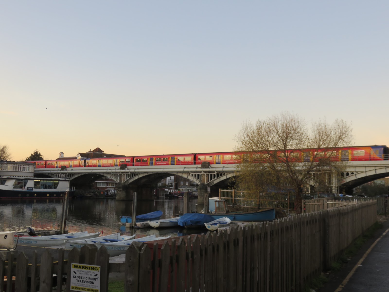
| Kingston Railway Bridge, first opened in 1863 then replaced with this iteration
in 1907. Railway bridges are more easily ignored than road ones, but in fact
have completely transformed all the towns along here. Consider how different
this entire stretch of the river might look if the trains had never brought
those crowds of middle-class Londoners out to settle it. |
 |
| Kingston Bridge, which ends today’s progress. This is one of the lower Thames’s
oldest bridge sites, with a permanent wooden bridge attested by 1219 but a
likelihood that still earlier versions existed. It has experienced a much more
turbulent saga of destruction and replacement than the bridges downstream, and
even now its strategic location makes it one of the busiest bridges in Greater
London. |
Formally
that completes the metropolitan stage of the Thames. But this corner was never
truly of London to begin with, and its course today seems to strive for more in
common with its rural upper provinces than its urban punch-through. When those of
leisured power got in their boats to ride away from the polluted air and angry democratic
demands from their workers and subjects, here is where they were first far
enough away to erect alternative worlds for themselves behind the high walls of
palaces, on the neverending fields of Arcadian dreams, and in the protective
rituals and jargon of watersports from the work-repellent hulls of pleasure
boats to the crimson-faced bellows of elite competitive rowing.
The
river had no responsibility for creating these social distinctions. Its water
was everybody’s to drink, fish and ride. But the English class inheritance runs
through everything the people of this land do, and though this heritage has
left them beautiful views, invigorating nature walks, and splendid buildings to
poke around in, the costs of transport and entry tickets in an age of disempowering
government policies and cultural attitudes still place them out of reach of
much of the population. The Arcadian dream still belongs to an exclusive English leisure class with permanent
housing, secure livelihoods, and a stake in their country's adult white masculinist power strucutres. No: not
until all its people have been secured the means to come and enjoy this
dream can they begin to ponder how far their country is developed or democratic.


No comments:
Post a Comment