
Today
we have a tale of two towns.
Chertsey
and Staines emerged for opposite reasons. One was for going to, the
other for going through. Each owed this to a singular crux: in one case a
house of the Christian cross, in the other a river crossing. Those structures
are long gone, yet the towns they birthed stand to this day as important
crossroads on the river. Add to that that one can hardly cross their paths
without being made cross at the political situation, which has seriously
crossed a line, and you begin to – well, that’s enough talking across them.
Although,
it really did cross a line. And don’t take my word for it. In the present
constituency, Runnymede and Weybridge, it was a line too far even for some
individuals on the highest balconies of the party responsible.
On
the electoral map we are now well into hardcore Tory Thames, blue surrounded by
blue. In the December 2019 election they changed their minion in parliament regardless.
This was because up till then it happened to be former Chancellor of the
Exchequer Philip Hammond. It isn’t anymore.
 |
| Chertsey Bridge is approximately the same colour as Philip Hammond’s lugubriousness. |
Hammond
controlled this country’s treasury during some of the cruellest years of the
Tory austerity programme and must take his share of responsibility for its dire
human rights abuses. Yet relatively speaking, he was a moderate: more concerned
with outcomes – however poorly he assessed them – than ideological zeal, preferring to deal in arguments rather than slogans. Ultimately this found
expression in a stubborn resistance to a hard Brexit which turned him into a
hate figure for the Brexit-rapture demagogues who clawed their way to power
under Boris Johnson. At the crunch, Hammond was one of twenty-one Tory MPs
expelled from the parliamentary Conservative Party, some of its grandest
veterans among them, for voting against Johnson’s Brexit deal. Like many other conservatives he has since wandered into the political wilderness, no longer at home in
a party he believes has left him.
It
is one of the many subplots of England’s present crisis, and one which will
most trouble the hearts of old Tory heartlands like this. The death of English
conservatism, a tradition devoured by its own children. It always had its
grievous flaws and made terrible mistakes. It had its part in the worst
atrocities of industrial exploitation and colonial racism. But somewhere in
there was also a more scrupulous dogs-and-meadows-and-fireplaces conservatism that
meant something better than violence against dissidents and minorities. An
honest and venerable tradition existed, born from legitimate shock at the
carnage of the civil wars and the French Revolution, whose instinct was to
place a steadying hand of caution on the shoulder of swift and hot-headed
change; that enjoyed discussing disagreements over tea and earnestly sought to
learn from them; that did not beat its chest about the wonders of industry and
empire, but made pragmatic use of those systems to try to do good with their
own little bits of them. A conservatism, that is, with integrity in its bones –
integrity which to the Brexit revolutionaries, in
their contempt for truth and hatred of dissent, has been totally indigestible. Those
bones, spat out with dripping conceit, are all that remain of the English
conservative tradition: scattered, lost, with a body no longer, washed away on
the river.
 |
| Today’s direction of travel: the view north atop Chertsey Bridge. |

But
that is what the river does. To the people who live on its floodplain, it
brings possibilities and it takes them away. But it does not choose from them. Only
they, the English and their predecessors and successors, can do that. Let’s
look at a few they did.
Start:
Chertsey Bridge (nearest station: Chertsey)
End:
Staines Bridge (nearest station: Staines)
Length:
6.4km/4 miles
Location:
Surrey – Borough of Runnymede, Borough of Spelthorne
Topics:
Chertsey Abbey, Laleham and the Earls of Lucan, the Penton Hook, Staines
Chertsey
Once
upon a time there was someone called Cirotis (or Ceorot, as the historian Bede
calls him, or Cerotus, which sounds like a Latinised variant). Of this
individual nothing is known. Their name is Britonic, not Roman or Anglo-Saxon.
And yet, it made enough of an echo for the Anglo-Saxon immigrants to give this
site the name of Chertsey, that is to say, ‘Cirotis’s Island’. And it
could easily have been an island back then, for it stands on a gravel outcrop in an area where all the water dumped in by tributaries like the
Wey give the river a marshy disposition.
 |
| Chertsey’s old town hall, built in 1851, at the head of its high street. A car crashed into its pillars last year which likely accounts for the nervous traffic barrier. |
From
the fifth to tenth centuries, the Thames valley’s strategic position and
resources made it hotly contested by the Anglo-Saxon kingdoms. This was not a
heartland but a shifting frontier, which the kingdoms of Kent (southeast), Essex
(east), Mercia (northwest) and Wessex (southwest) each controlled at least once. In
the course of these contests they converted from traditional Germanic religion
to Christianity, a complicated process that occurred for different reasons and
in different ways.
Out
of that process emerged the individual who put Chertsey on the map. Little is
known about Erkenwald (or Earconwald – Anglo-Saxon names are not standardised
in modern English) except that he came from another frontier area, Lindsey (now
Lincolnshire). It is believed he was of royal descent, possibly in the Essex
kingdom, which was powerful early on and underwent one of the most internally
turbulent Christianisations. Bede goes further and names him as the East
Saxons’ bishop. As the case may be, in 666 CE Erkenwald decided to come out
into this marshy, desolate and politically unstable middle ground to found the
first monastery in Surrey, Chertsey Abbey. This is not something you
just get up and do and suggests access to supportive people and resources (not
to mention that he founded a second abbey for his sister at Barking, which likewise
grew to great importance). These ventures seem to have done him little harm, because
after serving as Chertsey’s abbot for a few years he received promotion to
Bishop of London.
The
original monastery was built of wood and seems to have made a soaring start. It
received generous land grants from the Mercian client kings who came into
control of Surrey, and got to bury the bodies of high-status Anglo-Saxon saints
in its cemetery (always helpful because it means pilgrimages and therefore news
and money). But then it got killed.

The
Viking raid on Chertsey was not random. It fell under the steamroller of the
great Danish invasion of 865, which by the time it got here had swept aside the
Anglo-Saxon powers of the east coast – Northumbria and East Anglia – and would
soon overwhelm Mercia too. There is a great deal of debate about how much of
the Viking phenomenon was as violent as traditionally portrayed or in fact more
peaceful – the Christians had a tendency to exaggerate the monstrousness of people
not like them – but there seems little doubt that at its sharp end it was seriously
atrocious. Monasteries were glinting, undefended treasure chests of wealth and hostile
religious authority and therefore frequent targets, and Chertsey’s turn to
discover this the hard way came in 871 when Vikings on an expedition down the
Thames slaughtered ninety monks, Beocca the abbot and Ethor the priest among
them, pillaged the monastery’s riches, and laid waste to its lands. Then they
came back and did it again.
The
threat subsided after Alfred of Wessex defeated
the Vikings and they settled their conquered lands as the Danelaw, but
perhaps understandably this violence appears to have left lasting trauma. It is
only a century later that evidence arises of Chertsey Abbey getting rebuilt and
repopulated, and by monks sent from outside at that. They in turn were chased
off by King Edgar in 964 as part the Benedictine Reforms – a programme
driven by fear that monasteries’ wealth and influence were being exploited by
unserious monks, and thus aiming to give the rules and norms of monastic life
more rigour. From where we stand now that may look little more than some religious
quibble, but two patterns it strengthened would have enormous consequence later.
First, it stuck the king’s authority in the driving seat of religious affairs, which was fine if state and church got on well like Edgar with his Archbishop
Dunstan, but not so much if
your name is Henry. Second, it drew heavily and deliberately on
continental European standards.
Re-planted
with Edgar’s regularised monks, Chertsey Abbey escaped the turbulence of its
youth and from there the only way was up. King after king queued up to confirm
the lands it held and grant it more. It not only survived the Normans but won them
over, receiving extensive rights of hunting, foresting and security from
William the Conqueror in person. By the time of his Domesday survey in 1086 its
land was reckoned at over 50,000 acres, which only increased as his successors handed
it more and more. Then in the 1110s a new abbot undertook a massive rebuilding
programme, upgrading the church into a towering stone edifice and surrounding
it with a full-scale self-sufficient monastic complex of not only chapels, a
cloister and domestic buildings but brewing and baking facilities, vineyards,
apiaries, and a hydro-engineering project that turned a side-channel of the
Thames into its own Abbey River for drinking, cleaning, milling, fishing and
sewage.
Needless
to say, this was no longer some ascetic retreat in the middle of nowhere (if it
ever had been). In its heyday, Chertsey Abbey was one of the heftiest privilege
forts of the Thames valley: the brightest star of worship, wealth and scholarship
for miles around and by far the largest landowner in these parts short of the
king. When anything important happened in Surrey or anywhere near it, the Abbot
of Chertsey was sure to be there.
 |
| Chertsey Abbey’s entry in the Domesday Book, courtesy of the National Archives. Considerable paper is taken up to the list the widespread lands it held across Surrey and beyond. The Archives themselves feature in this earlier part of our river journey. |
Beyond
the Abbey walls, the Chertsey settlement began to thrive off its success. The village
grew into a town. The monks took an mounting role in its planning. In a matter
of decades it was an overflowing breadbasket of garden markets and commercial fairs
backed up by tile-making and brickworks and a leading centre of trade in this region.
 |
| The Abbey in the fourteenth century, re-imagined in a computer image in the Chertsey Museum. |
Obviously
something changed, because today the Abbey no longer exists and Chertsey is, if
far from destitute, one of the more modest beads on the Thames valley
necklace of glittering affluence. Much as today, the wealthy and successful get
to control how the history is written; look through the cracks however and
signs can be glimpsed of accumulating trouble.
The
monastery’s holdings turned its community into a bunch of rich landlords in a
world of downtrodden peasants and serfs. Then as now, as the victims of the
present housing crisis will attest, big landowners in the English story tend to
operate towards the villainous end of the spectrum. The National Archives records
petitions that indicate angry disputes between the Abbey and the tenants and
communities on its land. At times their grievances moved them to refuse to work
or pay rent, in which case chances were they would be violently repressed for
it. This was the kind of structural injustice that fostered the English middle
ages’ explosive rural upheavals, most famously the Peasants’ Revolt of 1381,
whose revenge was bloodily ferocious but whose underlying grievances were
legitimate and would persist.
 |
| A fifteenth-century map showing the Abbey and its dominance of the surroundings. Its mills, bridge and causeway highlight the underlying importance of the river in enabling its rise. |
Such
over-reliance on agricultural income from landholdings also exposed the Abbey
to shifts in the weather and shocks to the labour supply, most especially from
plagues like the Black Death. In spite of such vulnerabilities it kept up its
prestige, reaching a high point during the Wars of the Roses when it was
temporarily called on to bury the body of the almost certainly murdered King
Henry VI of the Plantagenet house of Lancaster (who had severe mental health
problems so English storytelling has not been kind to him). But by the rise of
the Tudors it appears to have crept into serious debt, and from there reports by inspectors grow more scathing. Accusations appear about obsessive
superstitions, dodgy relic stories, corrupt sales of land, and inevitably
sexual inclinations of kinds the authorities found easy to whip into public
prejudice.
It
is hard to assess the fairness of these criticisms because the bulk of them
came from the minions of Henry VIII, who as it turned out had
it in for the monasteries and actively fuelled such grievances to lay a
foundation for smashing them. But it is hard to imagine that without genuine
cracks in its fabric, Chertsey Abbey, one of the top-tier behemoths of the
English monastic system, would have given in as readily as it did. Many
monastic communities, like Syon
Abbey downriver, frustrated the king and his demolition squads for years
and often paid a gruesome price for it. Chertsey surrendered without a fight in
1537. The monks’ sole condition was that they be allowed to keep practicing somewhere
else, and they petered on upriver in Bisham, reduced from their erstwhile
abundance to grinding poverty. Only a few months later they were forced to
surrender again, when they were handed small pensions and this time dispersed
for good. For a powerhouse of half a millennium it must have felt a wretched
way to go.
Chertsey’s
monks might have got away with their limbs intact, but what did not escape
dismemberment was their great complex of buildings. Piece by piece it was picked
apart, its best stones and tiles cannibalised for Henry’s other palaces
(including Hampton Court) and the rest left to local scavengers. Knock on the
doors of some of the older houses in Chertsey and nearby villages and you can
probably still find some bits of it in their walls.
 |
| This is all that remains now. A bit of inner precinct wall and what’s thought to have been bread ovens (which would have been pleasant in a section with few pubs or cafés – thanks Henry). Some of its earthworks also survive nearby: a drainage ditch, and a few of its crucial fishponds which kept hundreds of fish and eels. |
 |
| Some of the most precious surviving pieces of Chertsey Abbey are its floor tiles, like these in the Chertsey Museum. |
Whatever
the political aspects of Henry Tudor’s assault on the monasteries, it was also
a colossal act of orchestrated historical vandalism. It destroyed not only
buildings but monuments, artworks and libraries full of manuscripts, of which
the monasteries looked after some of the oldest and finest in the country. This
puts Henry Tudor on a list he really should not want to be on that includes the
destructors of the ‘Four Olds’ in the Chinese Cultural Revolution, the Taliban,
Da’esh, and most recently, Donald Trump of the United States with his threats
to blow up Iranian cultural sites.
It also makes this a significant point on our river journey. Chertsey Abbey marks our first
encounter with a central Thames privilege fort that fell. This shows that they can
fall, but the circumstances are unfortunate because it was brought about by a far more oppressive and authoritarian locus of privilege – the
monarch – and would go on to enable the rise of another – the new landowning
class. Such is England.
But
before its collapse into rubble the Abbey did unwittingly sneak in one last
little surprise for the people who brought it to its end – a time-bomb of sorts.
In 1538, enough of its buildings remained serviceable for Henry VIII’s
Archbishop of Canterbury, Thomas Cranmer, to compile the Book of Common Prayer
here. This would later become the official prayer book of the English
Protestant church and a symbol of the authority of the monarch who now
dominated it. A century later it would be the flint that ignited the
conflagration of the civil wars when Charles I tried to impose it on the Scots
(whose Protestantism was different). In other words, though Chertsey’s power
had gone, it did get a last laugh of sorts by planting the seed of a quite
spectacular flower: a package of Protestant zeal that would drive the new
landowners in Parliament, the lopping off of the king’s head, and the ultimate
shunting of the institution which had wrecked it, the monarchy, out of the
English political scene.
Except,
of course, for the faction that were always uneasy about this and coalesced in
Parliament to fight back, at first for a continued strong monarchy, then, when
that became a lost cause, for fewer loppings of authoritarian leaders in
general. They came to be derided as tóraidhe or Irish bandits – Tories
– which brings us back to where we started.
 |
| Another index of Chertsey Abbey’s holdings from the fifteenth century is held by the National Archives and stands out because the scribe doodled all over the margins. At bottom left, he illustrates a nightmare about a terrible creature that would take power in this land six centuries later – notice how the top left appears to begin with a B, for Boris – and prophesies that it can only be forced to reveal its true form by inserting it through a lamp-post. |
So
descended Chertsey, which deprived of its nucleus had to make the best of
things. At least those things, inherited from the Abbey – a thriving
agricultural base, eminent name and strategic position on the river – could
have been worse. It recovered fast, then leapt on board the Wey
Navigation in 1777 and railways in 1848 to draw in new markets, tourists, a
dash of industry – particularly an iron foundry – and monied London bigwigs in
search of comfortable places to live (among them Charles James Fox, a
figurehead of the Tories’ bitter rivals the Whigs – later the Liberals, later
still a component of today’s Liberal Democrats). A further population expansion
came with the housing boom after World War II, which swelled Chertsey into
roughly the shape it holds today and looked to the local gravel pits for
construction materials. Today’s Chertsey no longer towers like the palaces of
Hampton below and Windsor above, but thus far it seems to have secured its roots well
enough in the wreath of Thames valley prosperity.
 |
| St. Peter’s Church in central Chertsey, built around 1300 as the town expanded though much restored since. |
 |
| Chertsey High Street. Observe how the shopfronts are roughly level, representing their core historic structures, while extensions of varying height and shape were later stacked on top. |
 |
| A monument to Blanche Heriot, one of Chertsey’s local heroes. The story goes that during the Wars of the Roses (1455-87), when the Yorkist authorities sentenced her lover to be ceremonially killed at the ringing of the curfew bell for fighting for the Lancastrians, she rushed to the bell tower, reaching it just in time, and grabbed the clapper to prevent it from ringing till a messenger could arrive with a pardon from the king. Whether this literally happened is unclear, but it is encouraging to see a community with stories where love correctly asserts precedence over political violence. Chertsey has both a major road and a unit in its NHS hospital named after Heriot. |
It
is not far upriver to the other town in this area, Staines. Yet the area in
between is not truly of one or the other. It cannot quite yet be called rural
because residential belts and public works have reached out to occupy most of
it, while it also provides passage for the principal river crossing in present
times, the M3 motorway. But parts of it do introduce a tinge of remoteness, a
sense of being neither here nor there. It is a hint that our journey slowly but
steadily begins to penetrate into the English interior.
 |
| Chertsey Lock, along with its weir one of several built in the 1810s to manage the Thames’s notorious navigational difficulties in these parts. |
 |
| Along with those difficulties has come a constant flood risk, which as recently as 2014 gave rise first to human tragedy and then to political controversy. When the river burst its banks that year the house of seven-year-old Zane Gbangbola was flooded and he died of gas poisoning. His parents, both professionals with environmental expertise, have presented evidence that the floodwaters came from a disused landfill site behind the house whose release of hydrogen cyanide killed their son. The government stands accused of a cover-up and pressure continues to mount for an independent inquiry. |
 |
| An old City of London coal tax post, indicating where tax was due on coal being shipped to London. This will be one of the last encountered on this journey – the City’s former jurisdiction ended at Staines. |
 |
| Growling and snarling, the M3 motorway monsters across the river. Today the main London-to-Southampton road, it was built in stages in the 1970s-90s and generated a major protest atop Twyford Down near Winchester for its threat of environmental destruction. The protesters were violently assaulted by private security officers who have never been prosecuted for it; their employers are now known as G4S and are infamous for grotesque human rights abuses worldwide. |
 |
| Several bodies of water alongside the river here appear to be filled-in gravel pits, perhaps dug for construction materials during this region’s post-WWII housing boom. Some have now been repurposed by watersports clubs. |
 |
| The river flows on. From here there will likely be more and more stretches that look like this. |
A smaller
road called Thames Side follows the river up to Laleham, perhaps the first true
village (as opposed to suburbanised village) on this route. Laleham had its own
manor house held by Westminster Abbey, whose old grounds we now encroach on.
 |
| The road from Chertsey to Laleham, with a playground marking the south end of the old Laleham manor grounds. |
 |
| The west bank here is taken up by the Chertsey Water Treatment Works. It has a little reservoir whose rim is visible here. This is also the start of a kaleidoscope of houseboats moored along the riverbank all the way to Staines. |
 |
| A couple of boat clubs are the only facilities amidst the willows on the east bank which probably give Laleham its name. There used to be more willows but many were lost in the Great Storm of 1987. |
 |
| A rosebush which has only produced one flower because of the election result. |
Laleham
The lael
in Laleham means twigs, most likely those harvested from the local willows to
make osier furniture. Positioned on a relatively straightforward site for a river
ferry, this village goes back to at least the tenth century when it appears in
the records of Chertsey Abbey, which of course controlled much of its
surrounding land. Henry VIII annihilated the option of a tasty baked lunch at
that monastery for this walk and therefore necessitated a brief inland
exploration of Laleham, which fortunately found a satisfactory alternative in a
local café that runs out of the pavilion of its cricket field.
 |
| Laleham’s outskirts as seen from the river. The roads look remote and are certainly not congested, but a fair bit of traffic does trickle along them. |
 |
| One of a series of quiet lanes that run between the river and village. River access must have been of prime importance and would probably make these some of Laleham’s oldest routes. |
 |
| Occasionally in the English interior one comes upon residences whose exteriors have been lined with eccentric figurines like this, often hatted, dressed up or otherwise equipped. This was the most eye-catching of this particular dwelling’s. |
 |
| Laleham’s All Saints Church. The brick tower is a 1730 replacement job but the structure’s oldest parts are more than 800 years old. |
Laleham’s
former manor house is called Laleham Abbey, which slightly misleads. It is not
an ancient monastery like Chertsey Abbey but a neoclassical mansion born as Laleham
House in 1805, which only picked up Abbey status because it was let out to a
community of Catholic nuns through the middle of the twentieth century. This
being England it is now private apartments, but previously it was notable for
the branch of the English nobility who made their seat here: the Bingham
family, better known as the Earls of Lucan.
That
might sound familiar on account of either of two members of it who pushed their
way into the history books for all the wrong reasons. One was the third
Earl, George Bingham (1800-1888), who carved a bloody trail of torture and
eviction through the population of Ireland during the great famine of the 1840s
before sallying off to command a cavalry division in the Crimean War, fought
with Russia over ostensibly a religious dispute but really to limit the
benefits to Russian power from the decline of the Ottoman Empire. His division
consisted of heavy armoured cavalry and fast light cavalry – the ‘Heavy
Brigade’ and ‘Light Brigade’ respectively. The latter, whose name might
instantly identify the calamity in question, was commanded by Lucan’s
brother-in-law; the two men despised each other. This may have influenced the
cavalry command’s miscommunications at the 1854 Battle of Balaclava whose
outcome was the Light Brigade charging headfirst into the maws of Russian
artillery and getting utterly blown to pieces for no reason. In the acrimonious
bickering that followed the other officers pinned responsibility on Lucan and
he was hauled back to England, where he continued to insist that he was right
and the others were to blame. But class is everything in England so his
reputation largely got away with it, while the disaster was reborn in imperial
romance as the Charge of the Light Brigade. An unpardonable mistake and scandalous
waste of life metamorphosed into a glorious tragedy about the courage and
heroism of ordinary British soldiers betrayed by the blundering donkeys in
command. They later got this narrative out again for World War I and have never really put it away.
 |
| The doom of the Light Brigade as it would have appeared from the Russian perspective, illustrated by the artist William Simpson who was present as a correspondent in that war. The disaster was swiftly immortalised in a poem by William Tennyson with verses like ‘Theirs not to reason why,/Theirs but to do or die./Into the valley of Death/Rode the six hundred.’ Moral: if you don’t ‘reason why’ then it could be you. |
The
other outstanding Lucan story isn’t much better. It concerns the seventh earl,
Richard John Bingham (1934-?), likely the Lucan known to the greatest number of
people because of his disappearance in 1974 in unsavoury circumstances. ‘Lord
Lucan’, as he remains known, lived a life marked by conspicuous gambling, drinking,
high-speed driving and boating, general extravagance and rancorous marriage
problems until he vanished into oblivion from his London home after apparently
attacking his wife and bludgeoning to death his children’s nanny, Sandra
Rivett, with a lead pipe. He was never seen again, and as is culturally typical
here the main concern has been less for the female victims of Lucan’s violent
upper-class masculinity and more for the legend that has grown up around the
possible whereabouts of what England’s sensationalist tabloid media has turned
into the titillating mystery of a dark and dapper aristocratic folklore figure.
Initial suspicions of suicide or escape abroad have since been overwhelmed in a
profusion of conspiracy theories and claimed sightings from West Africa to New
Zealand, with each lead pursued by police ending in frustration. He has since
been officially presumed dead, but it is unlikely his name has been uttered for the last time.
On
these ignominious notes, let us refrain from bothering the present Earl of
Lucan and instead head further up the river to where some interesting water
features await consideration.
 |
| The towpath out of Laleham leads to a tentacle of riverside housing which has stretched out from Staines, colonising what would otherwise be a backyard of fields and disused gravel pits turned into lakes. |
 |
| Boatworks punctuate the housing on the west bank. The gravel pits beyond found a more creative afterlife: their concrete company flooded them in the 1970s and raised upon them the Thorpe Park exhibition centre. It is now one of England’s top-tier amusement parks with rollercoasters, a hotel and themed rides, many involving water. |
 |
| This is the intake for the sizeable Queen Mary Reservoir, referred to in the previous section as one of the many waterworks around here. A lot of construction is apparent here at the moment, which a display by Thames Water claims to be for installing eel screens to protect the river’s collapsing migrant eel population. |
For
most of this section the river has glided gently along. Then all of a sudden,
for reasons known only to itself, it twists into an extreme loop of a meander.
It then curves back to within a stone’s throw of where it left and continues as
it was as though nothing has happened. This is Penton Hook, and it is
quite weird.
 |
| The main river course is at left, swinging back from its loop. At right it now short-cuts through the lock they built. |
 |
| The lock’s information display handily illustrates what’s going on here. The age of the loop is not clear but it is certainly older than the lock and weirs, which in part were installed because of the flood instability and navigational challenges caused by the river having, you know, living processes. |
 |
| Right in front of the lock, two ducks were engaged in a noisy and violent disagreement about whether allowing narcissistic bullies to use drones to kill anyone they don’t like on a whim makes the world a safer place. Naturally neither of them believes it does – only humans could be that ridiculous. The dispute is over whether it makes it dramatically more dangerous or, because humans have made it so dangerous already, only a little bit more dangerous. |
Penton
Hook looks like a classic case of ox-bow lake formation in
progress – or at least it was until they put the lock through in 1815 and broke
it. Before it had a lock on it the ‘neck’ used to flood on a seasonal basis and
indeed was narrow enough that impatient captains would sometimes force their
barges over it rather than bother to go all the way around. It would probably
have eroded and eventually become the main river channel, leaving the loop to
subside into a lake, but the English have made quite clear of late that they
like to have their cake and eat it so have engineered it in such a way that
they get to keep both the loop and the cut-off.
The
question then is how long it will last. It can be surmised that the river
dislikes their attempt to mess with it and they will have to keep sinking money
and labour in to keep it this way.
 |
| The lock turned the peninsula inside the loop into an actual insula. Penton Hook Island is seen here from the east side, atop the weir – you can see the river looping away at right and coming back at left. The island has been kept as a wooded green space and is used by the natives for fishing. |
 |
| Penton Hook Lock. The large weirs on both the loop and the cut-off appeared later to further help with flood relief, though there used to be smaller weirs nearby going back to the milling and fishing of the Chertsey Abbey days. |
 |
| Where there is a lock there is a lock-keeper’s cottage. Penton Hook Lock is the highest Thames lock that was built by the Corporation of London, whose former jurisdiction ends at Staines. Its cottage will therefore be the last on this route to display the City's shield of arms (top). |
Penton
Hook was also important to the Chertsey Abbey complex. In the course of its
great expansion in the eleventh and twelfth centuries the monks marched out
here to dig a side-channel coming off it into the Abbey River, their
very own parallel aqueduct to power their mills and water their fishponds. In
effect this turned the land between Penton Hook and Chertsey into an island,
the north known as Laleham Burway and the south as Abbey Mead.
The division suggests a long history of dealing and quarrelling between
Westminster Abbey, which held the manor of Laleham, and Chertsey Abbey which
held about everything else. Nowadays this middle ground is shared between a
golf course and the water works we saw earlier. In later times they dug out
more gravel to the west of Penton Hook, but this too has been filled and is now
a 600-berth marina, the largest such inland facility in Britain.
Staines
From
here the southward residential sprawl of Staines makes first contact
with the river, although the town centre is still some kilometres away. The
bulk is on the east side, outside of the river bend, which has at any rate
hosted the town’s centre of gravity since ancient times. After
industrialisation anything which didn’t fit spilled over onto the west side, including
the tail of riverside bungalows it has dangled all the way down to Penton Hook.
That bank was historically more rural but has long carried the name of The
Hythe, meaning a landing place or inland port (compare
Rotherhithe and its like in London), and was likely of great
strategic importance in that capacity with its access to Staines’s bridge.
 |
| The bungalows begin. From here to Staines the west bank has been almost entirely monopolised for this residential riverside romance. Most of the houses look like they were built or restored fairly recently. |
 |
| Obviously haunted. The bright pastel-colours and tropical plants should fool no-one. Look at the ‘antenna’ sticking out of the chimney, just waiting to catch lightning to awaken some unspeakable stitched-up horror which is then set loose on the land to vote Tory. |
 |
| Unusual colours on display. This is in fact the flag of Middlesex, whether the traditional county (abolished in 1965 because London had eaten most of it) or the old Anglo-Saxon kingdom (which might or might not have existed). It is not to be confused with the flag of Essex, whose kingdom controlled Middlesex in its formative days and whose flag is identical minus the crown on top. The swords are seax, from which the Saxons and both these kingdoms and provinces (as well as Wessex, Sussex etc.) got their name, and have served as a lasting symbol of Anglo-Saxon heritage. Conclusion: its display here indicates a desire for the resurrection of Middlesex as either a) a county or b) an independent kingdom. |
 |
| The riverside idyll continues. It is quiet and a little suspicious. |
 |
| Steps down to the river like these are common here and look considerably older than the houses. |
At
another meander the west-bank bungalows agglomerate into Egham Hythe, a
clutch of late nineteenth and twentieth-century settlement brought to the old
Hythe by industrialisation and the railways. Various large corporations still
keep their headquarters in the business parks between there and the west bank
of Staines.
 |
| The inside of the meander opens out to provide a small park between houses and water, where this animistic spirit was found accompanying a man panning for evidence of otherworldly material with his cap. |
 |
| A gathering of waterfowl by Egham Hythe. Swans appear of tremendous importance to Staines’s identity. |
 |
| The marker stone, again with the Corporation of London’s emblem, indicates Truss’s Island. This was near the limit of the City’s old responsibility for the Thames and by the end of the eighteenth century it had badly neglected it, with the water so obstructed and the towpath eroded that the City’s ancient rights over it were coming under scrutiny. It appointed a new Clerk of Works, Charles Truss, in 1774, who spent the next thirty years dredging and restoring this bend back to navigability and got this island named after him as thanks. |
 |
| Nowadays the towpath contends with different kinds of obstructions. But it is the attitudes that have changed, not the material itself: as a working towpath it must have been decked with horse deposits. |
 |
| And now Staines itself materialises on the horizon. |
Then
comes the final kilometre into town, where churches and pubs (which so often go
together) pop up in the gaps between the houses.
 |
| St. Peter’s Church faces onto the river, an 1894 late arrival to anchor Staines’s railway-driven southward expansion. Its construction was funded by the barrister Edward Clarke, better known for defending Oscar Wilde in his infamous trial the following year to the defiance of public and professional homophobia. |
 |
| Staines Railway Bridge, built in 1856 to carry trains between Waterloo and Reading. The yellow stripe along the top is a more recent addition, painted on in the 1990s to bring the bridge to the notice of flying swans so they don’t crash into it. |
 |
| Beneath the railway bridge the towpath gives way to urban Staines and switches to the western bank. Barges would push off the riverbank to cross, giving rise to cottages here that were named Hook On and Shoot Off. The horses that towed them on the towpath would be walked across Staines Bridge. |
 |
| And here is Staines Bridge in person. The present white granite span was opened in 1932 but the history of bridges on and near this site is much, much older and is what seems to have brought this settlement into existence. |
Staines
comes from Old English stānas, meaning ‘stones’ (recall the
‘stony ford’ of Stamford
Brook). This may refer to the great pile of gravel on which it is built, by
far the most significant patch of hard stone in an area of shifting soils and
marshes. It was only here, it is said, that you could ford the river without
having to put your foot on unstable ground.
But
this would have been of significance long before anyone speaking Old English
showed up here. The town precedes the string of Anglo-Saxon hamlets downriver,
and Staines is not its original name (nor its most recent, as we shall see).
There has been a permanent settlement here since at least the Roman invasion of
Britain in 43 CE, though the evidence of archaeology suggests its importance as
a river crossing goes back far further still. There are several candidates for
its name in Roman Latin, but their common motif is unambiguous: Pontibus,
ad Pontem or Pontes (‘at the bridges’ or simply ‘bridges’).
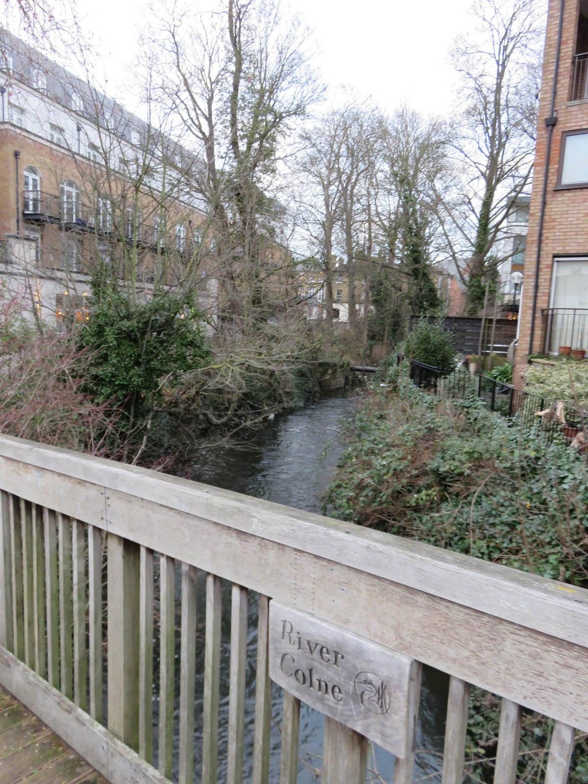 |
| Just short of the bridge the River Colne arrives from Hertfordshire. This tributary has put up with a lot of human interference, such as Grand Union Canal interactions and cuts to supply water features in both Syon Park and Hampton Court. But its valley further north is quite pleasant and can be experienced on the London Loop. |
In
England one of the most symbolic legacies of Roman occupation is their roads, paved
and shaped to superb engineering standards to assist troop movements and trade.
The image of the ruthlessly straight Roman road lingers in the English
imagination to this day as a stamp of Roman regimented authoritarianism that
has permanently disrupted the natural landscape, yet people continued to use
them long after the Romans left and in many places they form the basis
of the modern national network.
Staines’s
present site was where the main road west out of London reached the river again.
Its proposed Roman names are in plural form, suggesting they built not one
bridge but several. If this was a deliberate taking advantage of the ease of
fording at this site then it is likely the bridges determined the road placement and then the settlement's, much indeed as
with London itself. And once they made it across the river, the road continued
to the major crossroads town of Calleva Atrebatum (the Iron Age centre of the Atrebates
people, taken over and expanded by the Romans).
This
arrangement did not long outlast the Romans’ departure, after which much of
this route fell into disuse. Calleva Atrebatum was abandoned a few centuries
later in mysterious circumstances, possibly a result of this infrastructural
decline or of devastation by the Plague of Justinian; its ruins are now in the
shadow of the village of Silchester in Hampshire. At some point the road beyond
Staines acquired the name Devil’s Highway, suggesting a sense of mystery
or menace had overtaken its original purpose in the eyes of later inhabitants.
Nonetheless,
the site had taken on the life of its own that two millennia later presents us
with the current town. At first it was important because they came to cross the river, not to visit the ford in its own right. But bridges
concentrate hungry, tired and safety-conscious travellers in one place and are
ideal for people trying to sell them things, especially if one can unload them in
bulk onto armies or catch some governor or general passing by to lubricate
one’s prestige with their patronage. Then the merchants themselves need houses
to live in, as do the craftspeople who come in to build them. So grew the
town-by-the-bridges.
It
must have been important enough to make a long-term imprint, because though it
fades into obscurity after the Roman departure and the road system shifts
around it, it reappears in the records a thousand years later and appears quick
to resume business as usual, now under a new name. Stanes is listed in
the Domesday Book as a large settlement of 140 households under the control of
Westminster Abbey. Soon after that, three crucial things take place on its
watch one after the other. In 1215 a bunch of barons assemble there before crossing the river to a field, where they press King John’s nose into
the Magna Carta (to be encountered in the next instalment). The following
decade a bridge resurfaces in written records in the first of many requests to
the government for timber to repair it. Soon after that Staines’s ‘London
Stone’, marked 1285, appears by the river, a first sign of the City of London’s
assertion of its rights up to this limit that it would hold until 1857.
 |
| A replica of the London Stone now stands near its original spot in Staines. It has been re-carved, augmented and moved around many times since its beginning; the original is now in the Spelthorne Museum. It was customary for the City of London’s chieftain, the Lord Mayor, to parade up the river to ceremonially touch it, stopping of course to partake in a grand lunch. The presence of the bridge would have made an obvious landmark for this boundary, but it is unlikely a coincidence that Staines is also the highest point where the tide could be discerned before they installed the locks and weir at Teddington. |
With
all this attention Staines could hardly not revive itself into a bustling
medieval market town. Still on a strategic junction and at a convenient
distance from London for a first night’s rest for road and river travellers,
the processes which birthed it a millennium earlier repeated themselves as
churches and coaching inns sprang up, boosted by the produce of the farm fields
of Middlesex and Surrey while drawing traffic, commerce and big-named customers
with its proximity to sites of national significance like Chertsey Abbey and
Windsor Castle.
 |
| Staines wants people to know how much swans mean to it. This sculpture depicts a uniformed ‘swan-upper’, for whose tradition (as discussed at Kingston) Staines is a key centre. |
 |
| More sculptures depict origami swans behind Staines’s old town hall, an 1880 building and yet another piece of unique local heritage which Conservative Party planners have marked for conversion to luxury private apartments despite public pressure to keep it as a cultural and arts centre. |
 |
| More swans: the Swan Hotel, on the opposite riverbank upon the old Hythe. It is eighteenth century or older, refers specifically to swan-upping and traditionally provides the teams that do it with lunch. |
 |
| This isn’t a swan. A heron, more likely. I don’t know what it’s up to. Maybe it’s some ancient mythic thing like the owl statues in The Legend of Zelda games. You can save your game at it if heading upriver in case you get ambushed by nationalists at the Magna Carta place. |
From
there Staines nestles into the familiar pattern of the Thames valley towns,
embracing the fruits of industrialisation and the railways to swell with
housing and relatively genteel varieties of manufacturing to eventually take
the shape it retains today. Its standout was a massive Linoleum factory, built
in the 1860s to become the first and world-leading producer of that composite
floor covering, and the cornerstone of its economy, till its closure a century
later; the Two Rivers shopping centre stands where it stood now. Most of Staines’s
surviving buildings date from the same period, including its present bridge,
which despite the storied footprint it stands in has not been spared the other Thames
bridges’ catalogue of embarrassing design failures and replacements. This might
stem in part from its experience as a notorious traffic bottleneck after the
rise of the motor car, especially in holiday periods, a burden only relieved by
the M25 above and the M3 below in the late twentieth century.
 |
| The centre of Staines, with a sighting of the critically endangered Greater Spotted Debenhams. |
 |
| Staines’s high street commemorates its linoleum factory with this sculpture of two workers carrying a roll of the stuff. It even has a poem inscribed on it: ‘Roll out the lino/from Staines to the world!/Release every pattern/from chessboard to twirl!/In every hopeful kitchen/let life unfurl,/bathrooms are artrooms/from soapsuds to swirl!’ A celebration for a floor covering. For all the oppressions of England’s industrial system, its people found a great dignity in making things. It is hard to imagine anyone dreaming up verses like this about a shopping mall. |
 |
| Behold – not just any iron bridge as you find anywhere, but The iron bridge. The one and only. Tremble in fear. |
Thus
did a place for going through rather than to outgrow the
structures that birthed it and stake a new identity by the river, much as
Chertsey did after it lost its monastery. Yet in Staines there is one more
chapter which reminds us that history does not end in the present.
In 2012,
amidst some controversy, its name changed again: the town known for the best
part of a millennium as Staines became Staines-upon-Thames. This is now the
official name by which it appears on maps, but in recognition of persisting
dissent and respect for the spirit of democracy, which does not allow majorities
to impose things on people who have not consented, let us continue to call it
Staines till we can be sure everyone there is alright with the change.
It
might appear a trivial tweak, but names are important, not to mention expensive
to alter in a hyper-bureaucratic age – otherwise we might ask why the council went
to the trouble in the first place. The ostensible reason was to bring it in
line with the names of other settlements along the Thames and emphasise its
connection to the river. But this is not exactly convincing. They do not call
its neighbours Chertsey-upon-Thames or Windsor-upon-Thames, and
as we have seen there is no settlement whose riverine heritage better speaks
for itself along here than Staines, the town by the bridges. A different explanation
was soon doing the rounds of the newspapers: that the real reason was to break
the town’s association with Sacha Baron Cohen’s television character Ali G,
whose satirical portrayal of a gangster upbringing in the ‘Staines Ghetto’, it
is argued, did it a similar disservice to that done by Borat, another of
Cohen’s characters, to the nation of Kazakhstan. Staines’s chieftains want
business to come to it now rather than merely crossing through it, under
which consideration it seems they were upset at the thought of Ali G giving
them a repellent reputation. If so it is still unclear what adding -on-Thamesto its name does to change that, nor whether people won’t be bothered to get used to the extra syllables.
As
the case may be, Staines, upon Thames or not, is the place where this journey rests
for today. Once its name was moored to its bridges as Chertsey’s was to its
monastery, but clearly that is no longer the case. The river erodes their
stories much as it does the earth beneath them, liberating the fragments that
fall off when the humans break them but also bringing fresh nourishment to
nurture new ones, as though it never gives up hope they will learn the lessons.
If
this country really does head for ruin, then unless they truly screw up beyond
comprehension the river will still be there afterwards. Perhaps then, in
remembrance of the better things they made here, from linoleum to monastic
bread, they can rebuild something that will not, this time, project violence
out of this valley and around the world. Like the legacies of the abbey and
bridge, it may take a few hundred years, or a thousand. If these words somehow
survive that long and you are reading them in that era, please take a look and
see if they are still calling it Staines-upon-Thames.

A
special thank you to the Chertsey Museum for much of the information in this section.
No comments:
Post a Comment