
The
Chichibu-Tama National Park is a 1250-km2 expanse of
mountains, forests, river sources and rural towns and villages,
around the convergence of Tokyo's western extent with Saitama,
Yamanashi and Nagano prefectures. These mountains offer many of the
more serious hiking experiences within easy reach of Tokyo proper.
Mt.
Mitake (Mitake-san, 御岳山)
is a popular 929m peak at the edge of this region, in Tokyo's outer
district of Ōme. A cable car
provides access to the mountain village and prominent shrine, from where paths
into forested ridges and gorges connect to surrounding peaks. One
of these, Mt. Ōdake (Odake-san,大岳山),
lies across the district border between
Oku-Tama, Tokyo's largest and westermost district, and
Hinohara immediately south, and
at 1267m commands a view spanning from Kanagawa, via Mt.
Fuji, to the heart of the Kanto region's formidable mountainous
hinterland.


The area's paths are well-signposted throughout
and easy to follow. There are several routes between these two
peaks, of varying difficulties, but the one
detailed here proceeds through the Mitake-san "Rock Garden",
a forested ravine of splendid moss-covered rock formations and
waterfalls. Gradients are fair, though there are a number of steep,
sustained ups and downs, especially in that ravine and just before
the Ōdake summit. While not nearly as murderous as the likes of North Takao, the basic hiking essentials
(enough water/food, good footwear, a map and compass, good timing and
awareness, and a reasonable level of fitness) are
highly recommended.
Maps are available at the Mitake Station information centre
(especially of the happy-Japanese-cartoons variety; though closed on
Mondays), but obtaining a survey map of the Oku-Tama area in advance
(e.g. No.23 in the Mapple series) is suggested too.
Mitake-san – Ōdake-san
Length:
Approx. 11km (for the Rock Garden route; shorter paths available)
Hiking
Time:
Approx. 6 hours
Height:
Begins at Mitake upper cable car station, approx. 915m. Rock Garden
route requires a descent of approx 1-200m, followed by a climb back
up. The summit of Ōdake
is at 1267m, its approach posing the steepest climb.
Access (from central Tokyo):
1)
Go to Mitake
Station (御岳駅)
(Chuo Line or alternatives to Tachikawa Station, then JR
Ōme
Line to Mitake – make sure your train is on the main line for
Oku-Tama, and not the branch-off to Musashi-Itsukaichi!).
Depending on where you start, this will take approx. 1h30-2hrs
and cost approx. 1000 yen (one-way).
2)
A bus just outside the station goes to Ke-buru
Shita (bottom of cable car, ケーブル下)
in 10 minutes for 270 yen (one-way). Timetable here (out from
Mitake) and here (back to Mitake) – from left to right,
columns are weekdays, Saturdays, and Sundays/public holidays.
3)
The cable car runs approx. every 15 minutes: a ride either way is 6
mins. and costs 570 yen (two-way ticket for 1090 yen). The hike
starts and ends at the top.
SECTIONS:
1)
Mitake-san Village and Shrine
2)
Rock
Garden
3) Ōdake-san
4)
Return
1) Mitake-san Village and
Shrine
It can take a couple of hours to
get to Mitake Station (JR Ōme Line) from central Tokyo, so an early
start is worthwhile. Mitake station itself is small, and its
easily-navigable vicinity has an information centre, toilets, and a
7-Eleven convenience store. The bus to the cable car station, by the
orange sign, is literally one minute's walk away.


Once there, a short stroll uphill
leads to the cable car, which you should take to the top of
Mitake-san (6 mins.).


There is a quiet little village
around the peak, with souvenir shops and eateries, and already some
good vantage points over northern Tokyo and into Saitama. When ready,
take the path to the left out of the cable car station.


The
village is centred around the Musashi-Mitake
Shrine
(武蔵御嶽神社)
at the summit, supposedly established in 90 BCE and one of Japan's
oldest. Follow the signs there through snaking alleyways,
promenades and slopes.


 |
| The main approach to the shrine is lined with souvenir shops and small restaurants. |
20-30 minutes and a series of
stairs later, the shrine is worth an exploration. For more
information, see its website here.


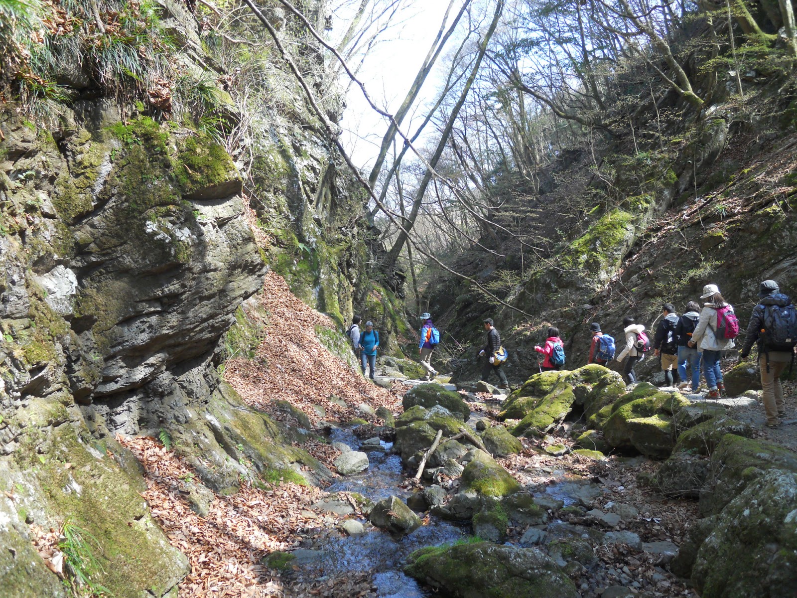
2) Rock Garden
The
real trek begins with the path southwest, through plantation
forests. Look for signs to the Rock
Garden
(ロックガーデン).
You can either go back down the stairs to the main route, or take a
shortcut down a narrow zigzagging path just on your right as you turn around from the shrine.
 |
| Shortcut path. |
You
will soon come to a fork. There are now multiple ways to proceed,
with the fastest being an easy path along the ridge (30-40 mins.) -
go right for this, and skip to part 3. However, the scenic route is
left, down into the ravine, which is more strenuous and takes a
little bit longer but passes a stream, two picturesque waterfalls and
the Rock Garden. This presents you with a sustained descent straight away, that eventually takes you to
the Nanayo
(“Seven Generations”) Waterfall.


 |
| Nanayo no Taki. |
From there the path climbs back
up through a sequence of narrow metal stairs and tree roots.

 |
| Tengu Rock (Tengu no ishi) at the top, after which the path becomes level again. |
Here
you are still in the ravine, but the way becomes much easier for a
time as it weaves through the Rock Garden's mossy stone formations
and waterways. Before long you reach Ayahiro
Waterfall.


 |
| Ayahiro no Taki. |

Now you have to climb back up to
the ridge. The passage is steep, but for the most part comfortable
and in good condition.


Within minutes you will rejoin
the main ridge path from Mitake-san.
3) Ōdake-san
Keep progressing upwards, and
soon the way is level once more. In around 15 minutes you reach a
fork at Akutaba Pass – here and wherever not otherwise indicated,
keep following the signs to Ōdake-san.
 |
| At this time of April, spring had yet to flourish at these heights. |
At this point you are within an
hour of the top of Ōdake, and
the trek to the top represents the most intensive climb of the hike.
Getting there requires negotiating a path that narrows, twists, and
at times calls for hand-assisted climbing. On the other hand, it is
safe enough in good weather, the rocks being solid and the path easy
to follow. Don't forget to look up as well as down for some of the
best perspectives over Tokyo yet.

When
you see a clump of large cabins, you are almost there. There is a
small clearing here with a torii
gate, a small shrine installation, and toilets just down the stairs
if needed. Just 15-20 more minutes' scrambling up rock gets you to
the summit.


At last you reach the peak, at
1266.5m altitude. This was the first day of clear weather for any
hike so far this season, though the sky was slightly obscured in the
distance.

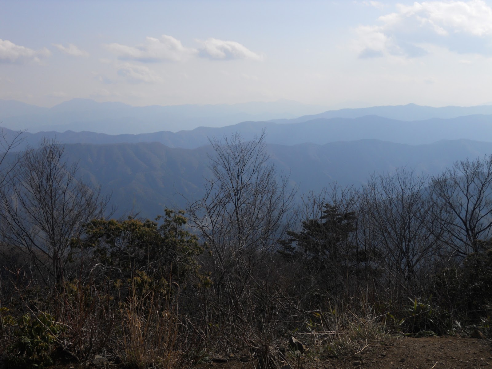

The
breadth of the view is impressive. To the left is southwest Tokyo and
northwest Kanagawa Prefecture, including the Tanzawa mountains. Spanning right are the mountains of east Yamanashi
Prefecture, and behind them on a clearer day, Mt. Fuji. Most
impressive of all are the looming blue enormities to the right: the
deeper peaks of Oku-Tama and beyond.
 |
| Hinohara, Tanzawa and Kanagawa. |
 |
| Oku-Tama. |
Keep an eye out for the local
wildlife! Flying squirrels are a common motif in the local signs and
artwork, but none made themselves apparent on this occasion.

 |
| Japanese Tit. |

4) Return
You now have a number of options
for heading back.
-Completing a circuit back to
Mitake-san requires first returning down the path you just climbed to
the fork at Akutaba Pass. There are three ways from here: the easy
middle route; the strenuous low path all the way back down through the Rock
Garden then up again; or the high-but-still-relatively-forgiving path
left, which returns via another peak, Nabewari-Yama (1084m). The last
of these was my original intent, but circumstances compelled a
diversion down the middle path, so unfortunately I cannot provide
details of the Nabewari route. From the Akutaba fork, either this or the middle route
should see you back to the village at Mitake-san in about 1 hour.
-For the really adventurous, it
is very feasible to keep going off the opposite (northwest) side of
Ōdake-san and on to Oku-Tama, the terminal of the Ōme Line by
Oku-Tama Lake, the source of much of Tokyo's drinking water. I do not
have experience of this route to advise on it, but one should allow
at least three hours for it, and ensure one still has time and energy
to complete it.
Sights from the ridge back to
Mitake-san:


Shortly before reaching
Mitake-san there is a branch-off beside a small drinks stall,
signposted to a viewing point and toilets. A short detour that way is
well worth it for the views, especially in the late afternoon sun.


 |
| Mitake-san in sight again. |
The
final cable car down is usually around 6:30pm, but make sure you
check in advance at the cable car station. In addition, the final
cable car on weekdays does not
make it down in time for the last bus to Mitake Station, so be sure
to plan enough time to get down earlier!


No comments:
Post a Comment