Showing posts with label autumn. Show all posts

Sunday, 31 January 2016

5) THE HAKKODA MOUNTAINS 八甲田山系 – The Wind Rages

A Voyage to Aomori, Part 5 of 5

  
There are those who claim that happiness has nothing to do with your circumstances, and everything to do with how you choose to respond to them. Such people seem quite numerous nowadays; whether more so than in the past I cannot say.

They are fools.

One does not simply choose to be happy. External circumstances matter. We have created societies that systematically break people. How callous, or plain ignorant, does a person have to be to expect anyone to accept and adapt to a world like that?

And yet, there are places our madness has not yet reached. Places free of arrogance, cruelty, poverty, gender or greed. Places that were there before us and will be there long after us. Places beautiful before anyone was around to corrupt the concept of beauty – a primordial beauty, one we cannot define but know at once when we see it, as though by an instinct as old as love itself.

It was a pain that should not have existed, brought on by the failure of human society, that drove me to Aomori in the distant north of Japan in search of respite. And on my final day there, I found one of the most formidable such places of beauty that I have ever known. It was unexpected – not part of the original plan. And it was guarded by some of the toughest combinations of weather and terrain I have yet encountered.

A location where big explosions once happened bigly.
But it was necessary. It was right. For the winds, the rocks, the trees, the skies, no matter how fierce, how rugged, how sharp, how cold, are not mad. Never have they hurt out of malice. They exclude and alienate no-one; all are welcome in their realm. Unlike society's, their conditions are fair. I could accept them with no hesitation. And in return for what they take, they give a thousandfold.

They give better external circumstances. Beautiful circumstances. Circumstances, if not for happiness, then at least for something magical and profound; something which speaks to your humanity at a level our shallow materialist individualisms no longer bother with.

The Hakkōda Snow March Disaster
Make no mistake, that does not mean the Hakkoda Mountains will not kill you if you do not approach them with care. The Aomori Fifth Infantry Regiment, a unit of the Eighth Division of the Imperial Japanese Army, learnt this in supremely miserable fashion back in the New Year of 1902.

Saturday, 10 October 2015

1) THE SHIMOKITA PENINSULA 下北半島 – A Bridge Between Worlds

A Voyage to Aomori, Part 1 of 5


It beckoned. Cold, remote and foreboding at the edge of Japan, an axe-shaped wildnerness unknown in the English-speaking world and far from everything.

The Shimokita Peninsula (下北半島) marks the northernmost frontier of Japan proper. It was one of the final territories to be reached and incorporated into the Japanese nation (apart from Hokkaido in the north and the Ryukyu Islands in the south, which are in essence different countries, though that is another story.) 

Long had I felt the call to explore these reaches. However, four years into my residence in Japan an impossible set of circumstances emerged in the face of which a retreat was the only option. Shimokita become the inevitable destination.


North, just as before – as on that voyage to that other world, Hokkaido, and those explorations of Tohoku around that time or since. But this time was different. This was a necessary flight to the fringes of this land, in search of a crossing to a very different kind of realm. 

Osorezan (恐山). The so-called mountains of fear, a mysterious beacon at the centre of Shimokita. Its name is well-known throughout Japan, for Buddhist mythology has it that it is the entrance to hell, and a place through which everyone must transit after they die. Its landscape is volcanic, sulphurous, bizarre, and charged with a strange spiritual energy: a place of dread to some, of peace to others, for it seems all react to it differently. This was the place I sought, though I cannot entirely say why. 

On the way I found there is more to Shimokita than its image suggests. Like most places considered remote, peripheral and empty, it seems Shimokita has long been exactly the opposite. For it guards the Tsugaru Strait (津軽海峡), a crossroads of history which has brought together people, information, cultures and goods from different lands over hundreds of years. Cold it certainly is, and out of the way to most of us it may be, but Shimokita reaches out for the worlds of the northern seas, on top of connecting those of the living and the dead, and has a beauty of its own that is one of a kind yet varied, subtle yet full of character.

Aomori Prefecture, in red, courtesy of Wikimedia Commons. Shimokita is its eastern peninsula. Together with the Tsugaru Peninsula (the western one) it encloses Mutsu Bay. To their north the deep Tsugaru Strait separates Japan's main island of Honshu from Hokkaido.

Shimokita.

It is here that we shall open this five-article series. It covers a journey that would continue on to Aomori city (bottom-left on the map above), and from there into the mountains and forests that stretch down this prefecture's centre. But let us start where that journey began: on a train that rocketed out of Tokyo one bleak end-of-summer morning. By the afternoon it had reached Aomori Prefecture, where I changed at Hachinohe then Noheji onto ever smaller trains, which finally trundled, as evening fell, up the windswept axe-handle of the Shimokita Peninsula.

Saturday, 15 November 2014

Kōshū Takaō-san (甲州高尾山), Yamanashi - The Winelands


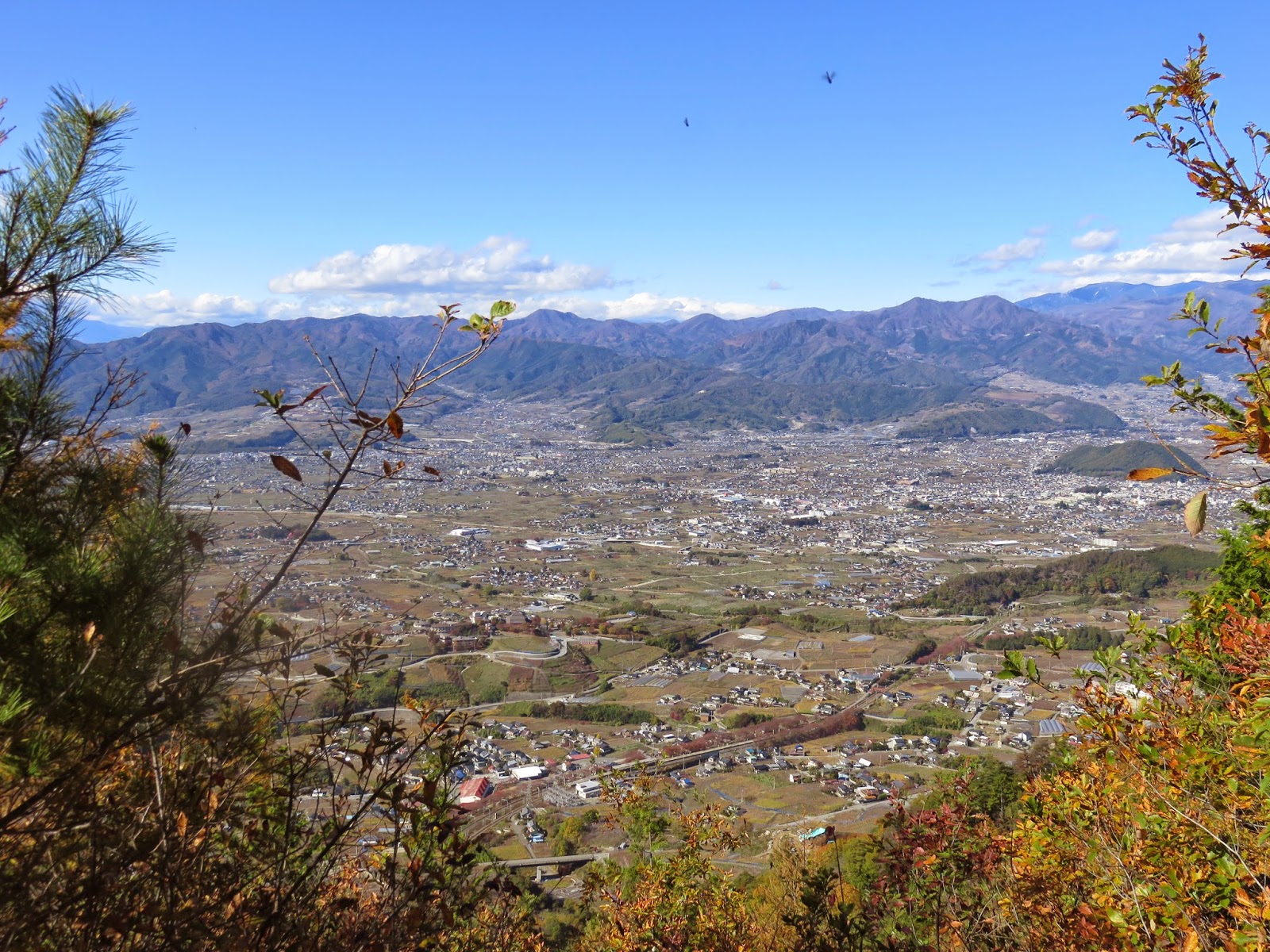
When you think of Japanese culture and industry, wine might not be the most iconic piece of heritage that comes to mind. Consider, however, Katsunuma (勝沼), in Kōshū (甲州), Yamanashi Prefecture, just west of Tokyo. Look closely at those buildings and fields.

 
The large buildings are wineries and wine-related facilities, and the fields are not rice paddies, but vineyards, producing Japan's most celebrated Kōshu variety of grapes. Katsunuma is the heart of Japanese wine production, responsible for almost half the country's total wine output, and if you believe the stories, this industry traces its origins back almost 1300 years.


Kōshū gets its name from an abbreviation for Kai (甲斐), the traditional province that became Yamanashi during the Meiji period (1868-1912). It is a landlocked zone centred upon the Kōfu Basin, which is ringed by towering mountains covered in forests. These rise to the north and west into the Japanese Alps; give way to the south to Mount Fuji; and extend east into the mountains of Oku-Tama (Tokyo) and Chichibu (Saitama).

Looking west across the Kōfu Basin. The large road is National Route 20, which roughly follows the old Edo-period Kōshū Kaidō (甲州街道) highway discussed here.
Katsunuma sits on the eastern edge of this basin, and above it rises 1,120m-high Kōshū Takaō-san (甲州高尾山) – not to be confused with the other Takaō-san in Tokyo. What follows here is a hiking route that takes in Kōshū's wine-making heritage, including a very old temple where it is said to have first begun, then launches into the bright mixed forests and breathtaking autumn ridges, where some more secretive shrines and temples hide in the deep wilds. This route can be walked in 5-6 hours, but be prepared for a punishingly strenuous climb from the temple to the Kōshū Takaō-san summit.


To get there, take the JR Chūō Line west out of Tokyo: past Tachikawa, past Hachiōji, past Takao (where you may have to change trains but on the same platform) and past Ōtsuki – but not as far as Kōfu. Get off at Katsunuma Budōkyō (勝沼ぶどう郷) station (“Katsunuma grape district”), where this walk begins and ends.

Friday, 31 October 2014

Mitō-san (三頭山): Three-Headed Mountain

Mount Fuji from the summit of Mitō-san.

Mitō-san (三頭, 1525m), the highest of the 'Three Mountains of Oku-Tama' in western Tokyo, is trickier to reach than the others. For one thing it is scarcely in Oku-Tama at all; it stands in the far southwest corner, on the boundary with Hinohara village and Yamanashi Prefecture. On the other hand, if you go there on a day with nice weather, you can get to see things like this.

 
Mitō-san – so named because of its clump of three summits – was apparently closed off to people in the Edo Period. This left it in peace to grow a splendid forest of huge beeches (buna, ブナ) and maples (kaede, カエデ), which still stand despite the dominance of sugi plantations in the area and display impressive colours in the autumn. This rich mixed forest also supports a thriving diversity of plant and bird life.


In a reversal of its former status, Mitō-san is now the centrepiece of the Hinohara Citizens' Forest (tomin no mori, 都民の森). The mountain and its surroundings are now open to everyone, with a well-equipped and well-maintained network of hiking trails and facilities which attract large numbers of people, although its relative remoteness stops it from getting overcrowded or detracting too much from immersion in nature.

There are multiple hiking routes to choose from, and they are generally quite easy – occasionally steep, but never punishingly so. This is definitely a mountain suitable for beginners, with a lot of cabins and information boards making it easy to navigate, rest or find support if needed. For more advanced walkers, longer routes out of the Citizens' Forest are also an option – you can go down to Oku-Tama Lake, or even up to Gozenyama if you are feeling ambitious enough.

The Citizens' Forest occupies the northwest corner of Hinohara Village, Tokyo. Mitō-san is in the top-left corner. To the north is Oku-Tama, to the west Yamanashi.

The biggest challenge lies in getting there. Hinohara, the last part of Tokyo still designated as a village (mura, ), is a sleepy place, whose mountain and forest coverage far exceeds its rail coverage. Unless you have a car, take the Itsukaichi Line (which branches off the Ōme Line) from Tachikawa to Musashi-Itsukaichi Station (武蔵五日市駅). From there, ride the Nishi Tokyo Bus (2014-5 timetable here) to tomin no mori (都民の森), although it may only run to Kazuma (数馬) where another bus will be waiting to take you the rest of the way. That's about 1 hour 10 minutes and 910 yen one-way, incidentally.

Click below for the full article.

Tuesday, 21 October 2014

Aizu (会津) - The Other Fukushima


This is Fukushima.

Yes, that Fukushima (福島). The prefecture in northern Japan brought to such suffering by the earthquake, tsunami and nuclear disaster in March 2011, since when it has joined a very long list in the company of places like Chernobyl, or Hiroshima, or Jonestown, wherein the very mention of the name evokes fear and disquiet. Wherein its entire story, its entire identity, in the eyes of those not in the know, is reduced to one defining calamity.

But let us get some perspective. Fukushima is large and diverse, the third largest prefecture in Japan, and is divided into three regions: to the west, historic and mountainous Aizu; in the centre, the well-connected Nakadōri; and to the east, the coastal Hamadōri. Of these, the nuclear disaster exclusion zone covers a segment of Hamadōri, and the vast majority of the prefecture is still safe to visit.

Aizu (red), Nakadōri (green), and Hamadōri (blue).

I recently had the good fortune of a weekend visit to Aizu (会津), which warrants special discussion in its own right. Historically Aizu was not only a separate domain, but a leading power in its neighbourhood overshadowed only by the rise of nearby Sendai under Date Masamune, who briefly occupied parts of it during his conquests. During the Edo Period (1603-1868), when Japan was unified under the Tokugawa shogunate, the Aizu lords became very close to the Tokugawa family and turned Aizu into one of the shogunate's most dedicated and loyal domains in the country. It was – and is – a proud territory, whose heritage reverberates to this day with echoes of the samurai and bushido warrior spirit.

This close relationship with the shoguns, however, transpired to Aizu's great sadness. Aizu is perhaps best known for its bloody defeat during the 1868-9 Boshin War, during the Meiji Restoration, in which the Tokugawa shogunate was overthrown and the Japanese emperor restored to power. Even after Edo (Tokyo) fell to the imperial forces, whose leaders and members came mostly from the southwestern domains of Chōshū and Satsuma, Aizu continued to fight on the shogunate's behalf at the core of a coalition of northern domains. Long one of the revolutionaries' bitterest enemies due to its extreme loyalty to the Tokugawas, Aizu put up ferocious resistance until it was crushed after a month-long siege of its capital at Aizu-Wakamatsu (会津若松).

Given the southern domains' special hatred for it, Aizu was dealt exceptional brutality during and after this conflict, with many of its people massacred, tortured, imprisoned or sent into exile. Furthermore, in an insult as unpardonable as insults came, the survivors were prohibited from tending to the bodies of their fallen, and these were left to decay in the streets. Aizu' defeat made the northern coalition untenable, and what remained of the Tokugawa loyalists fled Sendai for Hokkaido by sea, pursued by the imperial forces to their final destiny at Hakodate.

Tō no Hetsuri (塔のへつり), in Shimogō, southern Aizu.

I have seen it written that to this day, significant enmity, or even hostility, towards Chōshū and Satsuma remains in the hearts of many people in Aizu, who find it hard to forgive this ruthless treatment. For example, in 2006, this commentator observed the following:

A few weeks ago when I was in the city of Aizu in Fukushima, Japan, there was a panel discussion which included the mayor of Aizu...(involving) a letter from the mayor of the city that would have been the capital of Choshu (presumably Hagi) asking the governor of Aizu whether they could forget the past and just get along. The incidents were over 130 years ago. There was a heated debate that involved a lot of cheering and jeering from the audience, but it was clear that Aizu would not forgive these two clans...The panel pointed out that it was the victim that should reach out for peace, not the aggressors...The conclusion of the panel was that there would be no “forgiveness” but that “dialog” should continue.

Ouch.

The same account goes on to mention that because tending to the bodies of fallen Aizu soldiers had been forbidden, they were never commemorated at the Yasukuni Shrine, as is the custom for Japanese war dead. This supposedly gives many people in Aizu a uniquely negative view of government officials' visits to the controversial shrine; including by the current Prime Minister, Shinzo Abe, who in a further twist, happens to come from Yamaguchi Prefecture – that is, Chōshū.

Under the Meiji government, the old system of feudal domains was abolished, and replaced by what would become today's prefectural system. This was the end of Aizu as an independent domain, for it was joined to the rest of what would become Fukushima Prefecture, but to this day it remains highly conscious of its historical clout. It tells its stories and exhibits its identity at every opportunity, retains the name of Aizu in many place names and railway stations, and has built up a very strong tourism sector upon this heritage.

Akabeko, a symbol of the Aizu region.

Alas for unforeseen consequences. When Aizu was incorporated as part of Fukushima, nobody could have predicted that some hundred and forty years later the March 2011 Triple Disaster, in particular the spectre of nuclear radiation, would batter that tourism sector in the stomach for no more reason than this mere association of names. Even though Aizu was not so directly affected by the disaster – indeed, Aizu-Wakamatsu now shelters some thousands of people evacuated from the nuclear exclusion zone – its status beneath the very name of Fukushima has frightened off hundreds of thousands of visitors, both Japanese and foreign, especially because of the lack of rigour and transparency in how radiation safety was assessed and communicated.

Nonetheless, I hope that this article can provide a few insights and images, and help persuade you that a journey to Aizu, Fukushima is not only quite safe but certainly worth your while. Unfortunately my own trip was short; time and resources limited me to a small exploration of its south (Minami-Aizu, 南会津), and I did not get the chance to go to Aizu-Wakamatsu. Nevertheless, I saw splendid things. Click below for the full article.

Friday, 21 December 2012

Autumn Colours 3 - North Takao Ridge


After the South Takao Ridge, we now have its counterpart on the north side. The photographs in here come from two separate December hikes, catching the back end of 2012's autumn.

Again, you can find instructions and details here if you'd like to attempt this one yourself. This is among the best so far for splendid views, as north Takao is packed with deciduous woodland with fewer of the south's evergreen plantations, and frequent openings provide panoramas in both directions. To the north, Tokyo's sprawl subsides into spreading Oku-Tama mountainscapes, while the south offers the main ridge's colourful slopes and some impressive views of Mt. Fuji.


Be warned. This is a serious trek, and a jump up in challenge from the south or main ridge. Though you will not go higher than 731m, almost the entire route consists in steep climbs or descents, alternating unrelenting. The ridge is far less travelled than Takao itself, and there are few escape routes should you run into trouble once on it. Treat this walk with respect: go at a decent level of fitness, and bring a map and a compass as well as sufficient food and water. There are no toilets, so be sure to bear a toilet roll. And especially in winter, start walking as early as possible, to make sure you make it down before darkness sets in around 4:30-5pm; a flashlight is recommended just in case.

The paths are in good condition, not too rocky and often soft. Signposting is good, despite a few spots of confusion.


North Takao Ridge
Length: Approx. 14km. However, it will feel like a lot longer.
Hiking Time: Allow at least 7-8 hours.
Height: After the first hour-and-a-half's ascent to 556m (starting at 211m), the main section is an arduous 6km up and down a long series of peaks. Eventually the ridge merges into the Takao-Jinba ridge at Mt. Dōdokoro (堂所山), the walk's highest point at 731m. From there a sustained descent returns you to the road at 237m, with a final half-hour of flat pavement to Sagami Lake.

Access:
1) Go to Takao Station (高尾) on the Chuo or Keio Line, and go out of the North Exit.
2) From the bus terminal there, many buses go to the Hachioji Cemetery entrance (Hachioji reien-mae, 八王子霊園前) where the walk starts, including buses 1, 2 and 11. It only takes about 6 minutes to get there.
3) The walk ends at Sagami Lake and Sagamiko Station (相模湖駅), one stop past Takao Station on the Chuo Line.

Sunday, 2 December 2012

Autumn Colours 2 - South Takao Ridge


Following Sengenrei, here is some information on another nice autumn hike. Mt. Takao is one of the most popular and crowded mountains in the Tokyo metropolis: making it an all the more welcoming surprise that the southern ridge is comparatively secluded, tranquil and dense with foliage.

This route is longer and more rigorous than Sengenrei, with much more in the way of steep climbs and descents along an undulating ridge. At reasonable fitness however it should not be too challenging.

For those concerned, it is possible to skip about a third of the route here covered. The description here begins with Mt. Takao and Mt. Shiroyama, as previously featured, then swerves away to the south ridge. But if time, energy or stamina are limited, a short bus ride goes from the start point straight to the south ridge's ascent, cutting an hour or two and some of the steepest sections from the walk.

The south ridge follows the border between Tokyo Metropolis and Kanagawa Prefecture, to the north and south respectively. Though much of it is enveloped in woods and plantations, these occasionally break to provide great views over either. On a clear day, Mt. Fuji watches from the horizon.


South Takao Ridge
Length: Approx. 14km (9km if only doing the ridge itself)
Hiking Time: 5-6 hours
Height: Takao is 599m high, with easy options available for ascending it. Some gentle ups and downs follow the ridge to Shiroyama at 670m. From there to the south ridge requires a steep descent into the valley and ascent to get back up from it. The peaks of the ridge itself are about 450-500m high, with varying ups and downs between them.
Access:
1) Go to Takaosanguchi Station (高尾山口駅) (Chuo Line to Takao Station, then Keiō Takao Line one stop). You can start the hike from there, or...
2) Take a 15-minute bus ride from the station to Ōdarumi (大垂水) bus stop, if you are cutting out the Takao-Shiroyama section and only doing the South Takao Ridge.

Wednesday, 21 November 2012

Autumn Colours 1 - Sengenrei


In Japan, where coherent seasons are culturally meaningful and still in fact exist, kōyō (autumn colours) are to this time of year what sakura are to spring. Temperatures fall, and a cooling wave sweeps the green of the trees into reds and golds, progressing south as winter approaches.

It is a fine time to hike. The summer inferno has passed while the freezing bite of winter is yet to come, and clear skies are frequent. Here is the first of several examples: the Sengen Ridge, out west of Tokyo in the Akiruno (Akigawa/Itsukaichi) area. Another, the South Takao Ridge, will follow on here shortly, with likely more to come after that.


Sengen Ridge
Length: Approx. 10km
Hiking Time: 4-5 hours
Height: Up to 890m, starting from 255m. Early ascent (occasionally steep) is followed by relatively level and gentle paths along the ridge until a steep descent at the end.
Access:
1) Go to Haijima Station (Ōme Line from Tachikawa, or Hachikō Line from Hachiōji, both short distance), then change to the Itsukaichi Line to MUSASHI-ITSUKAICHI STATION (also short).
2) From Bus Stop 1 outside the station, take bus No.10 to Hossawa no Taki Iriguchi (Hossawa Falls entrance) – 22 minutes, 460 yen. The walk begins from that bus stop.